Millennium walk
A leisurely walk (riverside) starting and finishing in Tyne and Wear, England, about 9.00km (5.59 mi) long with an estimated walking time of about 2:30h. It is suitable for families with children, but unsuitable for prams & pushchairs, wheelchairs.
Elevation Profile
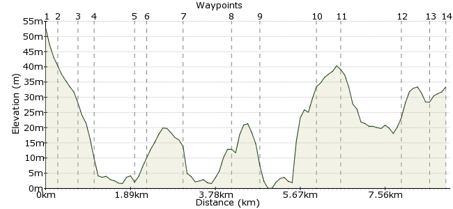
Ascent
49m (160ft)
Descent
68m (223ft)
Max. Elevation
60m (196ft)
Altitude Gain & Loss
117m (383ft)
Start
Byker metro station
End
Hebburn, Tyne and Wear, England
Distance
9.00km
(5.59mi)
(5.59mi)
Duration
~2:30h
Difficulty
Leisurely
Ordnance Survey Map
This walk takes in several of Newcastle's highlights: the quayside, the Millennium Bridge, the Baltic art gallery, the Riverside Park, Bill Quay Farm and many lovely places along the River Tyne.
Walk Functions
Share
Nearby Walks
Monkton meander
A leisurely, circular walk (riverside) starting in Tyne and Wear, England, about 9.30km (5.78 mi) long, duration: ~2:30h.Jesmond Dene
A leisurely, linear walk (city/town) starting in Tyne and Wear, England, about 4.70km (2.92 mi) long, duration: ~1:15h.Historic Tynemouth
A leisurely, circular walk (coast) starting in Tyne and Wear, England, about 3.70km (2.30 mi) long, duration: ~1:00h.Walk Map
- $walk->POI array(0)
Waypoints
OS Grid NZ270646
Start at Byker metro station.
OS Grid NZ267645
This runs alongside Dalton Street.
About 0.30 km (~0.19 miles) from 
OS Grid NZ267641
Continue along the old railway line to Rodney Street.
About 0.47 km (~0.29 miles) from 
OS Grid NZ265641
From Rodney Street continue to Quayside, crossing Walker Road (take care, it's a busy road, use the crossings).
About 0.26 km (~0.16 miles) from 
OS Grid NZ256640
Follow the riverside path to the bridge.
About 0.83 km (~0.52 miles) from 
OS Grid NZ259639
Cross the bridge and pass the Baltic art gallery along the river path to South Shore Road.
About 0.29 km (~0.18 miles) from 
OS Grid NZ266635
Follow the road to the cycle/pedestrian path.
About 0.78 km (~0.48 miles) from 
OS Grid NZ277632
Head along the path to Green Lane and down to a hotel for refreshments if required; if not, head up the road and turn left onto a cycleway.
About 1.10 km (~0.68 miles) from 
OS Grid NZ281630
Follow the path to Tyne Street and continue to the footpath at the other end, leading into a parkland area.
About 0.52 km (~0.32 miles) from 
OS Grid NZ293626
Continue to follow pathways along the river. At this point, you can choose to call in at Bill Quay Farm for refreshments; its worth the climb up.
About 1.25 km (~0.78 miles) from 
OS Grid NZ298627
After refreshments, continue to Davidson Road past the pub and on to a path.
About 0.46 km (~0.29 miles) from 
OS Grid NZ301641
You are now in Riverside Park. Follow pathways to a path crossroads and take the path up and to the left.
About 1.40 km (~0.87 miles) from 
OS Grid NZ302646
At the top of the path, turn left to Waterside Park housing estate.
About 0.53 km (~0.33 miles) from 
 Hebburn metro station
OS Grid NZ306647
Walk through the estate to Station Road and up to Hebburn metro station.
About 0.39 km (~0.24 miles) from 

2 comments... join the discussion!
Timwoods
Hi Jimmy, Yes, the website tends to underestimate slightly - it calculates as the crow flies between points, so doesn't include wiggles. Was it your walk? If so, I will enter your name into the prize draw. Thanks Tim
jimmy ward
walk is longer than stated and undulating but takes in many places worth seeing