Dorking to Gomshall - walk the chalk
A moderate walk (woodland) starting and finishing in Surrey, England, about 9.70km (6.03 mi) long with an estimated walking time of about 3:15h. It is suitable for families with children, but unsuitable for prams & pushchairs, wheelchairs.
Elevation Profile
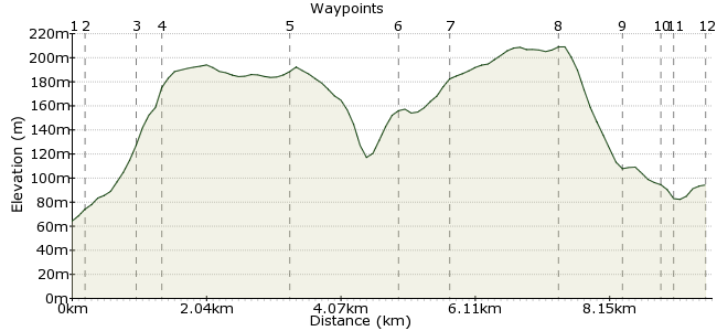
Ascent
197m (646ft)
Descent
167m (547ft)
Max. Elevation
210m (688ft)
Altitude Gain & Loss
364m (1193ft)
Start
Dorking
End
Gomshall, Guildford, Surrey, England
Distance
9.70km
(6.03mi)
(6.03mi)
Duration
~3:15h
Difficulty
Moderate
Ordnance Survey Maps
This route follows through the chalk downlands between the Denbies wine estate and the town of Gomshall. It's a fine stretch of the North Downs in Surrey, following parts of the North Downs Way as well as other woodland paths to get views across the scenery. Both start and finish stations are on the same train line, making it easy to get back to the start.
The chalk downlands are rich in wildlife; you might spot wild orchids, or some of the butterfly species that thrive in the well-managed grasslands. Look out also for badger setts near Gomshall. You might also spot some of the pillboxes that date from the second world war - the North Downs were an important look-out place.
Walk Functions
Share
Nearby Walks
Dorking to Reigate via Box Hill
A moderate, linear walk (low hills and fells (below 600m)) starting in Surrey, England, about 12.20km (7.58 mi) long, duration: ~4:00h.Up Box Hill the easy way
A moderate, circular walk (countryside) starting in Surrey, England, about 10.80km (6.71 mi) long, duration: ~3:45h.North Downs Way: Boxhill to Reigate
A moderate, linear walk (low hills and fells (below 600m)) starting in Surrey, England, about 11.70km (7.27 mi) long, duration: ~4:00h.Walk Map
- $walk->POI array(0)
Waypoints
OS Grid TQ159499
Take the train to Dorking West Station.
OS Grid TQ160500
Turn left at the end of Station Road and into Ranmore Road, towards the Denbies wine estate.
About 0.18 km (~0.11 miles) from 
OS Grid TQ154502
Turn off Ranmore Road along a bridleway to Denbies.
About 0.71 km (~0.44 miles) from 
OS Grid TQ151505
Beyond the vineyards, join the North Downs Way and head west.
About 0.39 km (~0.24 miles) from 
OS Grid TQ132500
Follow the track for about a mile, ignoring paths to the left and right. Continue on to Landbarn Farm. Here, take the lower footpath (left fork) to walk along the edge of the woodland for a closer look at the vineyard and farmland.
About 1.99 km (~1.24 miles) from 
OS Grid TQ120489
Continue along the footpath, then follow the switchbacks uphill to join the North Downs Way at White Downs.
About 1.60 km (~0.99 miles) from 
OS Grid TQ113487
Cross the road and continue along the North Downs Way.
About 0.72 km (~0.45 miles) from 
OS Grid TQ097487
Continue along to Hackhurst Downs.
About 1.55 km (~0.96 miles) from 
OS Grid TQ090481
Take the path heading diagonally downhill, towards Gomshall.
About 0.94 km (~0.58 miles) from 
OS Grid TQ085481
Head to Colekitchen Lane. Look for the badger setts in the banks along the roadside.
About 0.53 km (~0.33 miles) from 
OS Grid TQ084479
At Station Road, follow the signs to the station.
About 0.14 km (~0.09 miles) from 
 Gomshall Station
OS Grid TQ088478
Finish your walk at the station.
About 0.43 km (~0.27 miles) from 
