Disley to Lyme Park circular walk
A leisurely walk (low hills and fells (below 600m)) in Cheshire, England, about 8.70km (5.41 mi) long with an estimated walking time of about 3:00h. It is unsuitable for families with children, prams & pushchairs, wheelchairs.
Elevation Profile
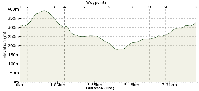
Ascent
189m (620ft)
Descent
180m (590ft)
Max. Elevation
400m (1312ft)
Altitude Gain & Loss
369m (1210ft)
Start & End
Disley
Distance
8.70km
(5.41mi)
(5.41mi)
Duration
~3:00h
Difficulty
Leisurely
Ordnance Survey Map
This is a very pleasant and easy walk. There is a climb upto the Bowstones but it is mostly downhill and level after that. It should be an easy 3 -4 hours outing.
Walk Functions
Share
Nearby Walks
The Gritstone Trail
A hard, linear walk (countryside) starting in Cheshire, England, about 53.60km (33.31 mi) long, duration: ~18:15h.Gritstone Trail around Bollington and Rainow
A strenuous, circular walk (low hills and fells (below 600m)) starting in Derbyshire, England, about 21.20km (13.17 mi) long, duration: ~7:30h.The northern edge of Kinder Scout
A moderate, linear walk (low hills and fells (below 600m)) starting in Derbyshire, England, about 12.90km (8.02 mi) long, duration: ~4:45h.Walk Map
- $walk->POI array(0)
Waypoints
OS Grid SJ972846
Start at Disley Station. Head along Market Street, then turn right down towards Bentside.
OS Grid SJ973842
Turn left onto Green Lane and there is a sign for the Gritstone Trail shortly afterwards.
About 0.37 km (~0.23 miles) from 
OS Grid SJ979832
Keep on the Gritstone Trail.
About 1.23 km (~0.76 miles) from 
OS Grid SJ975830
Shortly after turning right, turn left to head south/southeast, still on the Gritstone Trail.
About 0.45 km (~0.28 miles) from 
OS Grid SJ980821
Keep heading south to Cock Knoll. Pop into the nearby Moorside Grange Hotel if you fancy a mid-walk drink.
About 0.97 km (~0.6 miles) from 
OS Grid SJ973813
At Bowstonegate, leave the track and take the path across Park Moor, which is National Trust land.
About 1.15 km (~0.71 miles) from 
OS Grid SJ963817
Follow the track through the woods.
About 1.04 km (~0.65 miles) from 
OS Grid SJ964825
Join the North Cheshire Way towards Coalbit Clough.
About 0.82 km (~0.51 miles) from 
OS Grid SJ965832
Head over Coalbit Clough, heading north.
About 0.73 km (~0.45 miles) from 
 Disley again
OS Grid SJ972845
Keep heading north, then retrace your steps back into Disley.
About 1.43 km (~0.89 miles) from 

2 comments... join the discussion!
Timwoods
Thanks for the feedback Andy. I have corrected the note about turning right not left. I haven't done this walk, but the Green Lane might not be signposted as green lanes are a type of footpath, so it might mean that rather than a named street. See: http://en.wikipedia.org/wiki/Green_lane_%28road%29 We divide our walks into linear and circular, in that linear start and finish at different points, while circular take you back to the same starting point. So circular walks can, by our definition, include a bit of backtracking.
Andy
I'd firstly like to say these directions were completely useless. Green Lane for one is not signposted you have to guess and cross a field to the first sign for gritstone trail in which this says turn right. When you should actually be going left. We managed to figure it out but you completely miss boasting. And it's not a circular if you have to 'retrace' your steps. Don't use this guide it's a complete waste of time