Bryn Euryn and Rhos Heritage
A leisurely walk (coast) in Clwyd, Wales, about 6.60km (4.10 mi) long with an estimated walking time of about 2:00h. It is suitable for families with children, but unsuitable for prams & pushchairs, wheelchairs.
Elevation Profile
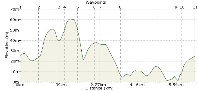
Ascent
58m (190ft)
Descent
59m (193ft)
Max. Elevation
70m (229ft)
Altitude Gain & Loss
117m (383ft)
Start & End
Colwyn Bay
Distance
6.60km
(4.1mi)
(4.1mi)
Duration
~2:00h
Difficulty
Leisurely
Ordnance Survey Map

Walk Functions
Share
Nearby Walks
Colwyn Heights
A leisurely, circular walk (countryside) starting in Clwyd, Wales, about 5.80km (3.60 mi) long, duration: ~2:00h.Xmas Day circular from Colwyn Bay
A moderate, circular walk (countryside) starting in Clwyd, Wales, about 15.20km (9.44 mi) long, duration: ~4:30h.Circular E, S. and W. from C/Bay.
A moderate, circular walk (coast) starting in Clwyd, Wales, about 14.00km (8.70 mi) long, duration: ~4:15h.Walk Map
- $walk->POI array(0)
Waypoints
OS Grid SH841794
Accessible by bus from east and west i.e. Rhyl, Llandudno, Conwy. Head west to mini roundabout, exit first left downhill, past garage, through traffic lights and on to footbridge.
OS Grid SH834794
Cross into Tan-y-Bryn Road, don't turn off, but go straight on to see road sign for Bryn Euryn.
About 0.64 km (~0.4 miles) from 
OS Grid SH833801
Turn left to wooden sign for Bryn Euryn nature reserve. Turn right, up steps, and follow path to ruins of Euryn Hall and history board.
About 0.73 km (~0.45 miles) from 
OS Grid SH832801
Exit to left, at waypost marked 'summit walk / woodland walk'. Go left on the summit walk, then semi-circular right. At summit, go downhill to path on right. Follow this to meet woodland path and turn left, downhill past rear of houses to exit onto Dinerth Road.
About 0.12 km (~0.07 miles) from 
OS Grid SH827801
Turn right, continue on to garage, see Saint Trillo's Church. Cross road, admire church and graveyard.
About 0.44 km (~0.27 miles) from 
OS Grid SH831806
Go on to see Hickorys Smokehouse Pub / Restaurant, a great asset to the area, recently opened, checkout hickorys.co.uk for online menus and booking.
About 0.59 km (~0.37 miles) from 
OS Grid SH832805
Turn left downhill. Don't turn off, but go straight on to promenade.
About 0.14 km (~0.09 miles) from 
OS Grid SH836812
Turn right, go down path on left to lower level. You will pass probably the smallest church in UK. (seating 6), kiddies' play area, Rhos Point shops for fishing sundries, boat trips, kayak and boarding instruction, etc. On the right is Rhos Fynach (old priory) pub / restaurant. Stay on promenade past Cayley Embankment to pelican crossing at Toad Hall.
About 0.78 km (~0.48 miles) from 
OS Grid SH846794
Cross the road, then uphill under railway bridge to Prince's Drive.
About 2.03 km (~1.26 miles) from 
OS Grid SH845792
Turn right and follow the road to the traffic lights at West End.
About 0.17 km (~0.11 miles) from 
 End of walk
OS Grid SH841794
Hope you enjoyed it, tell your friends!
About 0.44 km (~0.27 miles) from 
