Beneath Kinder Scout
A moderate walk (countryside) in national park Peak District in Derbyshire, England, about 12.50km (7.77 mi) long with an estimated walking time of about 5:00h. It is unsuitable for families with children, prams & pushchairs, wheelchairs.
Elevation Profile
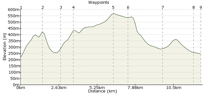
Ascent
494m (1620ft)
Descent
466m (1528ft)
Max. Elevation
570m (1870ft)
Altitude Gain & Loss
960m (3148ft)
Start & End
Chinley
Distance
12.50km
(7.77mi)
(7.77mi)
Duration
~5:00h
Difficulty
Moderate
Ordnance Survey Map
If you have done Kinder and are looking for an alternative, this is the route for you. This is also an option if the weather's not good for a day on the tops. Rather than head up to the peat hags, this walk follows the paths that furrow beneath its south-west corner. The Manchester to Sheffield line is your transport - stations lie at each end.
Walk Functions
Share
Nearby Walks
Gritstone Trail around Bollington and Rainow
A strenuous, circular walk (low hills and fells (below 600m)) starting in Derbyshire, England, about 21.20km (13.17 mi) long, duration: ~7:30h.The northern edge of Kinder Scout
A moderate, linear walk (low hills and fells (below 600m)) starting in Derbyshire, England, about 12.90km (8.02 mi) long, duration: ~4:45h.Lantern Pike from Hayfield
A leisurely, circular walk (low hills and fells (below 600m)) starting in Derbyshire, England, about 7.50km (4.66 mi) long, duration: ~2:45h.Walk Map
- $walk->POI array(0)
Waypoints
OS Grid SK040827
Take the train to Chinley.
OS Grid SK037842
The path runs beneath the grassy crag at Chinley Churn.
About 1.54 km (~0.96 miles) from 
OS Grid SK048842
Drop down to Chinley Head and cross the road carefully.
About 1.17 km (~0.73 miles) from 
OS Grid SK056846
Just above is Mount Famine. Climb it.
About 0.86 km (~0.53 miles) from 
OS Grid SK083851
From here, follow the long shoulder of Brown Knoll, just below Kinder Scout.
About 2.73 km (~1.7 miles) from 
OS Grid SK080861
Just north, between Brown Knoll and Kinder, runs the Pennine Way. Drop down the northern slope to meet this icon of British walking.
About 0.99 km (~0.62 miles) from 
OS Grid SK102853
The Pennine Way leads you through Upper Booth, a small hamlet at the far end of the Vale of Edale.
About 2.30 km (~1.43 miles) from 
OS Grid SK123858
As you can imagine, the path is fairly well trodden en route to Edale. You shouldn't really get lost here.
About 2.15 km (~1.34 miles) from 
 Edale Station
OS Grid SK122853
After a pint in the pub, walk through the village to the station for the train home.
About 0.49 km (~0.3 miles) from 
