Abergele
A leisurely walk (coast) in Clwyd, Wales, about 4.60km (2.86 mi) long with an estimated walking time of about 1:45h. It is suitable for families with children, but unsuitable for prams & pushchairs, wheelchairs.
Elevation Profile
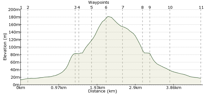
Ascent
167m (547ft)
Descent
163m (534ft)
Max. Elevation
190m (623ft)
Altitude Gain & Loss
330m (1081ft)
Start & End
Abergele
Distance
4.60km
(2.86mi)
(2.86mi)
Duration
~1:45h
Difficulty
Leisurely
Ordnance Survey Map
 1Created by driver 16 on 13 Apr 2013
Abergele is a former market town dating back to Roman times, which nestles between the sea and woodland-covered hills. It takes its name from 'Aber', denoting the mouth of a river, and 'gele', originally from 'Gelau', which means the blade of a sword or the tip of a spear in old Welsh.
This is 1 of 5 walks around Abergele. All routes are waymarked and may cross stiles, uneven ground, wet areas and paths with steep sides (children must be supervised). Places of interest include St. Michael's Church, Gwrych Castle (a rich man's folly), tower hill, the mount, castell cawr (an ancient hill fort) and of course the views.Â
Photos on Flickr at: http://www.flickr.com/photos/driver_16/
Walk Functions
Share
Nearby Walks
Abergele - Tower Hill
A leisurely, circular walk (countryside) starting in Clwyd, Wales, about 5.00km (3.11 mi) long, duration: ~1:45h.Rhyl-Rhuddlan-Rhyl
A leisurely, circular walk (riverside) starting in Clwyd, Wales, about 9.20km (5.72 mi) long, duration: ~2:30h.Rhuddlan Castle and Dyserth Falls.
A leisurely, circular walk (countryside) starting in Denbighshire, Wales, about 8.90km (5.53 mi) long, duration: ~2:30h.Walk Map
- $walk->POI array(0)
Waypoints
OS Grid SH945777
Take the path at the rear of bowling green, turn left into church grounds, then take the path past the church through the Lych Gate to exit onto a main road.
OS Grid SH945775
Cross, then turn right to follow the main road to see a stone gate entrance to Gwrych Castle. Don't go in, but turn left. Follow the road uphill past the golf club to find an entrance on the left to some woods.
About 0.13 km (~0.08 miles) from 
OS Grid SH933771
Turn left up a forestry track. Follow this round to see an earth mound.
About 1.19 km (~0.74 miles) from 
OS Grid SH934771
Great views East, West and North over the town, and towards Rhyl, the Clwydian Hills, Gwrych Castle, Llanddulas, the golf club and wind farms. Head back down to the forestry track; look for the wooden steps on the left of the track. Climb these to cross Ffos-y-Bleiddiaid (Wolves' Ditch).
About 0.10 km (~0.06 miles) from 
OS Grid SH934769
Crosses Ffos-y-Bleiddiaid, a deep narrow gorge, and a potential roost for bats. Follow the path which has steep drops on the left side - PARENTS, WATCH CHILDREN - to Castell Cawr, an Iron Age hill fort.
About 0.27 km (~0.17 miles) from 
OS Grid SH936767
An Iron Age hill fort and a Scheduled Ancient Monument. Take in the great views south over the valley and distant hills. Descend through the forest to see the road to a farm.
About 0.33 km (~0.21 miles) from 
OS Grid SH935763
Turn left and follow the road to meet a minor road.
About 0.36 km (~0.22 miles) from 
OS Grid SH939765
Turn right. Look up to your right to see the remains of a quarry, from which stone was taken to build Bryngwenallt Hall which you will see shortly. Look for a public footpath sign on your left.
About 0.45 km (~0.28 miles) from 
OS Grid SH940765
Enter and look right, over the wall, to see Bryngwenallt Hall. Follow the path over two estate roads to meet the main Llanfair road.
About 0.14 km (~0.09 miles) from 
OS Grid SH943768
Turn left and follow the road into town to see the pelican crossing from earlier.
About 0.44 km (~0.27 miles) from 
 End of walk
OS Grid SH945775
Hope you enjoyed it. Should you have time to explore more of Abergele, this is 1 of 5 walks: pick up a walks leaflet from the library, or return to the bowling green where there is a history board detailing all the walks.
About 0.73 km (~0.45 miles) from 

1 comment... join the discussion!
Thomas Stuart trevaskiss.
I would particular to look out for what varied wild creatures I could see.is a route map available for this country walk.to save carting my iPad about with walk information on.