Surrey Hills and Ales
A moderate walk (countryside) in Surrey, England, about 17.20km (10.69 mi) long with an estimated walking time of about 5:45h. It is unsuitable for families with children, prams & pushchairs, wheelchairs.
Elevation Profile
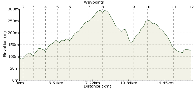
Ascent
276m (905ft)
Descent
245m (803ft)
Max. Elevation
300m (984ft)
Altitude Gain & Loss
521m (1708ft)
Start & End
Gomshall
Distance
17.20km
(10.69mi)
(10.69mi)
Duration
~5:45h
Difficulty
Moderate
Ordnance Survey Maps
 Car Free Walks TeamCreated by GaryShipp on 23 Nov 2007
Stroll around this beautiful part of South East England, with views across the Weald to the South Downs beyond, and some fine country pubs en route.
Walk Functions
Share
Nearby Walks
Gomshall to Westhumble
A moderate, linear walk (low hills and fells (below 600m)) starting in Surrey, England, about 11.90km (7.39 mi) long, duration: ~3:45h.A taste of the Surrey Sandstone Hills
A leisurely, circular walk (countryside) starting in Surrey, England, about 6.80km (4.23 mi) long, duration: ~2:15h.Dorking to Gomshall - walk the chalk
A moderate, linear walk (woodland) starting in Surrey, England, about 9.70km (6.03 mi) long, duration: ~3:15h.Walk Map
- $walk->POI array(0)
Waypoints
OS Grid TQ088478
Start of the walk
OS Grid TQ089473
Leave the road behind and head out into the hills.
About 0.43 km (~0.27 miles) from 
OS Grid TQ096469
Head straight over.
About 0.83 km (~0.52 miles) from 
OS Grid TQ105459
Worth a detour for its Real Ales
About 1.28 km (~0.8 miles) from 
OS Grid TQ115459
Another hostelry of note!
About 1.07 km (~0.66 miles) from 
OS Grid TQ127457
With the Stephen Langton Pub little more than a stone's thros away.
About 1.23 km (~0.76 miles) from 
OS Grid TQ127438
If the clock allows, then take the path South Easterly and head for the top of Leith Hill. Otherwise, turn west and onwards to Holmbury Hill.
About 1.88 km (~1.17 miles) from 
OS Grid TQ139431
The highest point in SE England, and over 1000ft thanks to the Victorian viewing tower on top. Climb the stairs for a small fee or be distracted by the fine selection of home made cake in the kiosk at the bottom (seasonal opening times apply). Stunning panorama, with both London and the sea in view.
About 1.37 km (~0.85 miles) from 
OS Grid TQ111441
The name of which escapes me but I'm sure it's something to do with the name of the village of Holmbury St Mary. There's another up the road to, by the church and with a name related to the Royals.
About 2.95 km (~1.83 miles) from 
OS Grid TQ103429
The Iron Age folk beat the Victorians to this one and built a fort on top. Wonderful views from 270 degrees and a little less busy than it's taller neighbour. Without cake buying facilities though . . .
About 1.44 km (~0.89 miles) from 
OS Grid TQ086447
A mountain bikers mecca at weekends. Great for some food for the train journey home.
About 2.49 km (~1.55 miles) from 
 Any which way you can
OS Grid TQ088464
Choose your route depending on energy and then back from whence you came.
About 1.77 km (~1.1 miles) from 
