Chrome Hill
A moderate walk (low hills and fells (below 600m)) in national park Peak District in Staffordshire, England, about 10.80km (6.71 mi) long with an estimated walking time of about 3:45h. It is suitable for families with children, but unsuitable for prams & pushchairs, wheelchairs.
Elevation Profile
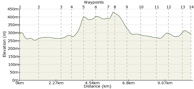
Ascent
206m (675ft)
Descent
209m (685ft)
Max. Elevation
440m (1443ft)
Altitude Gain & Loss
415m (1360ft)
Start & End
Longnor
Distance
10.80km
(6.71mi)
(6.71mi)
Duration
~3:45h
Difficulty
Moderate
Ordnance Survey Map
Small hills can be deceptive; Chrome Hill is a mere 425m, but its appearance is more of a mountain, with a fine rock-smattered ridge. This walk includes a bit of Peak District countryside on the way there and back – never a bad thing.
Regular buses run between Ashbourne and Buxton, stopping at Longnor. It's a good family walk, but there are a few road sections.
Walk Functions
Share
Nearby Walks
Two rivers - the Dove and the Manifold
A moderate, circular walk (countryside) starting in Derbyshire, England, about 15.70km (9.76 mi) long, duration: ~5:15h.Hartington to Wolfscotedale
A leisurely, circular walk (riverside) starting in Derbyshire, England, about 8.90km (5.53 mi) long, duration: ~2:45h.Derbyshire delights in Dovedale
A moderate, linear walk (riverside) starting in Derbyshire, England, about 14.90km (9.26 mi) long, duration: ~4:30h.Walk Map
- $walk->POI array(0)
Waypoints
OS Grid SK089649
Start your walk in Longnor.
OS Grid SK095659
A bridleway across the River Dove takes you to Underhill.
About 1.19 km (~0.74 miles) from 
OS Grid SK083665
The perfect place for a snack?
About 1.36 km (~0.85 miles) from 
OS Grid SK077668
Follow the road beneath Parkhouse Hill to the foot of Chrome Hill.
About 0.67 km (~0.42 miles) from 
OS Grid SK070672
From the road, head up the steep-looking slope of Chrome Hill.
About 0.78 km (~0.48 miles) from 
OS Grid SK067678
Stay on the high ground to Tor Rock.
About 0.70 km (~0.43 miles) from 
OS Grid SK060682
Pick up the footpath at Stoop Farm, which leads on to Hollins Hill.
About 0.72 km (~0.45 miles) from 
OS Grid SK060678
The second peak of the day; nice views back across to Chrome Hill.
About 0.39 km (~0.24 miles) from 
OS Grid SK061670
On the western edge of the hill is another footpath leading to Hollins Farm.
About 0.80 km (~0.5 miles) from 
OS Grid SK067665
Into Hollinsclough, a small farming hamlet nestled in the Peaks.
About 0.79 km (~0.49 miles) from 
OS Grid SK077668
A permitted path takes you back to Parkhouse Hill. Climb it if you want to.
About 1.00 km (~0.62 miles) from 
OS Grid SK081662
Different way back; take the south-east footpath to the road, then turn right.
About 0.70 km (~0.43 miles) from 
OS Grid SK086655
Pass through Under the hill and back into Longnor.
About 0.88 km (~0.55 miles) from 
 Longnor
OS Grid SK087649
There are a few pubs in the town if you have a wait for the bus; the local recommendation, though, is the Packhorse Inn in nearby Crowedicote, a short walk away. Buses between Buxton and Ashbourne stop here too, making this a good option.
About 0.60 km (~0.37 miles) from 
