Roman Caernarfon
A leisurely walk (city/town) in national park Snowdonia in Gwynedd, Wales, about 1.50km (0.93 mi) long with an estimated walking time of about 0:30h. It is suitable for families with children, prams & pushchairs, wheelchairs.
Elevation Profile
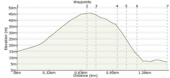
Ascent
31m (101ft)
Descent
40m (131ft)
Max. Elevation
50m (164ft)
Altitude Gain & Loss
71m (232ft)
Start & End
Caernarfon
Distance
1.50km
(0.93mi)
(0.93mi)
Duration
~0:30h
Difficulty
Leisurely
Ordnance Survey Map
 1Created by driver 16 on 02 Sep 2013
A stroll out of Caernarfon about 1/2 mile (about 20mins) to Segontium Roman Fort. At the moment the visitor centre and small museum are closed for re-furbishment; they should be open again for 2014.
It's quite an extensive site with plenty to see. Don't miss the foundations and remains of a retaining wall. This short walk could be combined with my other walk, 'Caernarfon, Castle and town walls'. Allow at least 3hrs.
In the castle is the Royal Welsh Fusiliers museum on 3 floors, including a 20 minute film show, 'From Eagles to Dragon' on Roman times to the present, and a video of Prince Charles' investiture. The 'Segontium Roman Fort' pamphlet by Jeffrey L. Davies is available from Cadw online shop for £2+£2.95 p&p.
Walk Functions
Share
Nearby Walks
Caernarfon, castle and town walls
A leisurely, circular walk (countryside) starting in Gwynedd, Wales, about 8.00km (4.97 mi) long, duration: ~2:15h.Brynsiencyn
A moderate, circular walk (countryside) starting in Isle of Anglesey, Wales, about 10.90km (6.77 mi) long, duration: ~3:15h.Llyn Padarn
A leisurely, circular walk (countryside) starting in Clwyd, Wales, about 7.70km (4.78 mi) long, duration: ~2:30h.Walk Map
- $walk->POI array(0)
Waypoints
OS Grid SH480627
On the one-way street, go in the direction of traffic to a T-junction. Turn left into the square. Be careful in the flagged square; there's no tarmac and no kerbs, but traffic is allowed through. Follow direction for 'Segontium'.
OS Grid SH485623
It's currently closed for refurbishment, but should be open for 2014. In the meantime, see photos at Flickr, in popular tags enter 'carfreewalks', which takes you to my photo stream.
About 0.67 km (~0.42 miles) from 
OS Grid SH485623
Don't miss the foundations of the old main entrance, the bath house and the retaining wall.
About 0.10 km (~0.06 miles) from 
OS Grid SH483623
To the left of the car park are the remains of a Roman wall, which formed part of a large warehouse for the import and export of goods using the river below.
About 0.20 km (~0.12 miles) from 
OS Grid SH482623
Cross the pelican crossing from Derwen. Just before the garage, see the plaque on the wall, 'Hen Walia', which dates from the 3rd century.
About 0.06 km (~0.04 miles) from 
OS Grid SH481623
Follow the route back to the square, passing the Welsh Highland narrow gauge railway below and a view of the castle.
About 0.05 km (~0.03 miles) from 
 Railway offices
OS Grid SH479625
If you want to, continue with my walk out into the countryside: 'Caernarfon, Castle and town walls'. Or visit the castle itself (allow 3 hours in the castle to take everything in).
About 0.30 km (~0.19 miles) from 
