Knucklas to Knighton - Offa Hoppa Walk 5
A leisurely walk (low hills and fells (below 600m)) starting and finishing in Powys, Wales, about 6.50km (4.04 mi) long with an estimated walking time of about 2:15h. It is unsuitable for families with children, prams & pushchairs, wheelchairs.
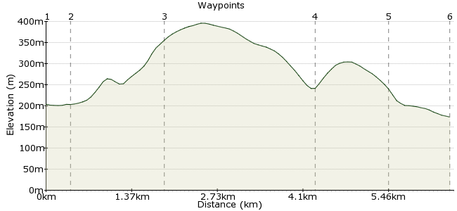
Elevation Profile
Ascent
153m (501ft)
Descent
183m (600ft)
Max. Elevation
400m (1312ft)
Altitude Gain & Loss
336m (1101ft)
Start
Knucklas
Distance
6.50km
(4.04mi)
(4.04mi)
Duration
~2:15h
Difficulty
Leisurely
Ordnance Survey Map
A moderate 5 mile walk from Knucklas to Knighton with a steady climb to Bailey Hill to meet Glyndŵr’s Way which passes through hill country and through an old quarter of Knighton to the Narrows and Clock Tower.
Walk Functions
Share
Nearby Walks
Knucklas to Knighton
A moderate, linear walk (countryside) starting in Powys, Wales, about 14.70km (9.13 mi) long, duration: ~5:15h.Five Turnings to Knighton – Offa Hoppa Walk 6
A leisurely, linear walk (low hills and fells (below 600m)) starting in Shropshire, England, about 4.10km (2.55 mi) long, duration: ~1:15h.An Offa's Dyke taster - Knighton to Presteigne
A moderate, linear walk (low hills and fells (below 600m)) starting in Powys, Wales, about 11.70km (7.27 mi) long, duration: ~4:00h.Walk Map
- $walk->POI array(0)
Waypoints
OS Grid SO253741
Catch the Heart of Wales Line train (or bus) from Knighton to Knucklas to start the walk. Leave the railway station and walk down a road, known as Glyndwr, by houses to a junction. Go left and pass by the bus shelter (where bus walkers join). At the fork in the road, pass to the right of the Castle Inn. Before the bridge go left as signposted to Heyope (Heyop). However, you might like to make a detour to the Knucklas community orchard and climb steps to the earthworks of Knucklas Castle. There are a number of sculptures to admire on the way. Go over the bridge and look for steps on the left into the orchard.
OS Grid SO250742
Otherwise, keep ahead at the first junction and then go under the Knucklas viaduct to take the first turn left. Follow this lane out of the valley. Ignore the left turn by Cuckoo’s Nest and climb more steeply until you see a barn on the left. Look for a stile on the right by a barred gate. Cross this and climb slightly right up a slope between gorse bushes. Cross a stile and follow a line of hawthorns to go over another stile. Head slightly right, across the field, to a stile in a fence. Cross it and continue in a similar direction to cross a stile onto a lane. This area is known for the grazing of local sheep varieties such as the Beulah speckled face, Clun Forest, Kerry Hill and Hill Radnor.
About 0.34 km (~0.21 miles) from 
OS Grid SO245728
Turn right to walk along the lane for approximately 200 yards and turn left through a barred gate. Continue ahead on a track but before reaching the next gate, go left to descend to a pool with a hedge to the right. Go through a gate and rise again with a hedge to the left. Go through another barred gate and keep ahead on a track to descend into a valley. Pass by a farm on the left before arriving at a junction.
About 1.48 km (~0.92 miles) from 
OS Grid SO267723
Go left here to climb up a lane beneath Garth Hill. Ignore the first turn right but go right at the second junction. As this road bends to the left keep ahead on a green track into a wood and through a bridle gate. At the junction take the higher path to rise up to another bridle gate. Go through it and there’s a good view of Knighton below as you make your way along this section. Pass by a cottage to a road junction.
About 2.33 km (~1.45 miles) from 
OS Grid SO279721
Turn right to walk up the road to a corner where you cut left on a narrow path between hedges. Go left down a drive, cross the road and once over follow an urban path between gardens to a lane. Take the right fork into the valley bottom near to a stream. The lane narrows by cottages and then bends slightly right to a road junction. Keep left to climb the hillside to Castle Road which loops around to the top of the Narrows. One of Knighton’s castles was situated near here; parts of the earthworks remain on private ground.
About 1.13 km (~0.7 miles) from 
 Knighton
OS Grid SO288723
Walk down to the Clock Tower and turn right down the main street. Go left opposite the Knighton Hotel to return to the railway station along Station Road or for the bus station (the first right turn into Bowling Green Lane).
About 0.93 km (~0.58 miles) from 
