From Zennor to Morvah on the Cornish coast
A leisurely walk (coast) starting and finishing in Cornwall, England, about 7.40km (4.60 mi) long with an estimated walking time of about 2:15h. It is unsuitable for families with children, prams & pushchairs, wheelchairs.
Elevation Profile
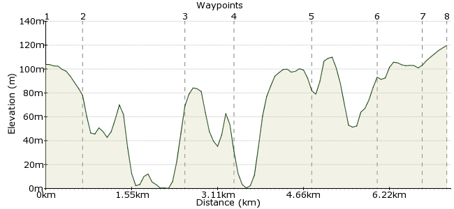
Ascent
89m (291ft)
Descent
73m (239ft)
Max. Elevation
120m (393ft)
Altitude Gain & Loss
162m (530ft)
Start
Zennor
End
Madron
Distance
7.40km
(4.6mi)
(4.6mi)
Duration
~2:15h
Difficulty
Leisurely
Ordnance Survey Map
This walk takes in a superb stretch of the Cornish coastline. Heading south from Zennor, the route hugs the coastline above its many cliffs and bays, and there's the chance for a bit of scrambling at Gurnard's Head as well.
The Cornwall Explorer buses connect the two villages with Penzance.
Walk Functions
Share
Nearby Walks
The Zennor Coastal Circular
A leisurely, circular walk (coast) starting in Cornwall, England, about 6.00km (3.73 mi) long, duration: ~2:00h.St Michael's Way
A leisurely, linear walk (low hills and fells (below 600m)) starting in Cornwall, England, about 9.70km (6.03 mi) long, duration: ~3:15h.YHA Penzance to Trengwainton Gardens
A leisurely, circular walk (countryside) starting in Cornwall, England, about 3.90km (2.42 mi) long, duration: ~1:00h.Walk Map
- $walk->POI array(0)
Waypoints
OS Grid SW454384
Take the bus to Zennor on the north Cornish coast.
OS Grid SW450389
Follow the path towards Zennor Head and Pendour Cove. From here, navigation is easy - just keep the sea on your right!
About 0.63 km (~0.39 miles) from 
OS Grid SW432383
Look out for the sea birds swirling around Gurnard's Head.
About 1.82 km (~1.13 miles) from 
OS Grid SW425377
Much of the coastline along this walk is managed by the National Trust, including this stretch near Porthmeor Point.
About 0.90 km (~0.56 miles) from 
OS Grid SW417367
Continue past the site of Bosigran Castle, an Iron Age cliff castle.
About 1.33 km (~0.83 miles) from 
OS Grid SW408359
Keep heading along the coast to Long Carn.
About 1.18 km (~0.73 miles) from 
OS Grid SW401358
When you see the church in Morvah, take the footpath away from the South West Coast Path towards the village.
About 0.74 km (~0.46 miles) from 
 Morvah
OS Grid SW401353
Pick up the coastal bus at Morvah, by the telephone box. Or you can continue into nearby Pendeen (about another half an hour) for a pub.
About 0.46 km (~0.29 miles) from 
