Mynydd Bodafon
A leisurely walk (low hills and fells (below 600m)) starting and finishing in Isle of Anglesey, Wales, about 8.90km (5.53 mi) long with an estimated walking time of about 2:45h. It is unsuitable for families with children, prams & pushchairs, wheelchairs.
Elevation Profile
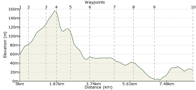
Ascent
119m (390ft)
Descent
154m (505ft)
Max. Elevation
160m (524ft)
Altitude Gain & Loss
273m (895ft)
Start
Brynrefail
End
Moelfre
Distance
8.90km
(5.53mi)
(5.53mi)
Duration
~2:45h
Difficulty
Leisurely
Ordnance Survey Map
A hill-and-coast combo on this North Wales romp. Mynydd Bodafon is a small hill in Anglesey but what it lacks in stature, it makes up for this with its great views. The peaks of Snowdonia are visible on a clear day, and there are views across to the coast to the north. There are no big climbs, but it's a good workout nonetheless. A shorter option is available by missing out the coastal section, but that would be a shame.
Walk Functions
Share
Nearby Walks
Moelfre
A leisurely, circular walk (coast) starting in Isle of Anglesey, Wales, about 6.10km (3.79 mi) long, duration: ~1:45h.Amlwch to Llaneilian
A leisurely, circular walk (coast) starting in Isle of Anglesey, Wales, about 8.20km (5.10 mi) long, duration: ~2:30h.Llangefni - the Dingle Llyn Cefni & Oriel Ynys Mon
A leisurely, circular walk (countryside) starting in Isle of Anglesey, Wales, about 6.50km (4.04 mi) long, duration: ~2:00h.Walk Map
- $walk->POI array(0)
Waypoints
OS Grid SH479869
Start the walk at Brynrefail, a stop on the route from Bangor to Amlwch. Let the driver know you want to get off here, as I think it's a request stop.
OS Grid SH478864
Look for the footpath behind the church.
About 0.48 km (~0.3 miles) from 
OS Grid SH472858
A jumble of footpaths around the hill, but it's easy to see the route up.
About 0.87 km (~0.54 miles) from 
OS Grid SH472854
A short climb to the top, rewarded with views across to Snowdonia.
About 0.42 km (~0.26 miles) from 
OS Grid SH470847
Cross the road to the south of the hill, leading to the corner of a forest.
About 0.65 km (~0.4 miles) from 
OS Grid SH480845
Follow the track along the edge of the forest and cross the small stream. At the footpath junction, turn left towards the coast.
About 1.00 km (~0.62 miles) from 
OS Grid SH485857
Through another small woodland and into the campsite.
About 1.28 km (~0.8 miles) from 
OS Grid SH486865
At Rhos Ligwy, you can return along the main road back to Brynrefail, or continue walking towards the coast.
About 0.82 km (~0.51 miles) from 
OS Grid SH493872
At Lligwy Bay, take the Wales Coast path heading east.
About 1.02 km (~0.63 miles) from 
 Moelfre
OS Grid SH512866
The path continues into Moelfre, where you can catch the same bus back home.
About 1.91 km (~1.19 miles) from 

4 comments... join the discussion!
patrikG
I know, Pete, it's great to have you on CFW. It's all fun, innit ;)
driver 16
Hi Patrik, didn't want to make a big issue of it, you know how well I get on with you all, Pete.
patrikG
Anglesey it is. An honest mistake and the first one young Tim's made in his life. I've just corrected it.
driver 16
Anglesey with a Y not an a, sorry Tim you made the same with my walk at Brynsiencyn !!!!!