Holywell 2
A leisurely walk (countryside) in Flintshire, Wales, about 8.40km (5.22 mi) long with an estimated walking time of about 2:45h. It is suitable for families with children, but unsuitable for prams & pushchairs, wheelchairs.
Elevation Profile
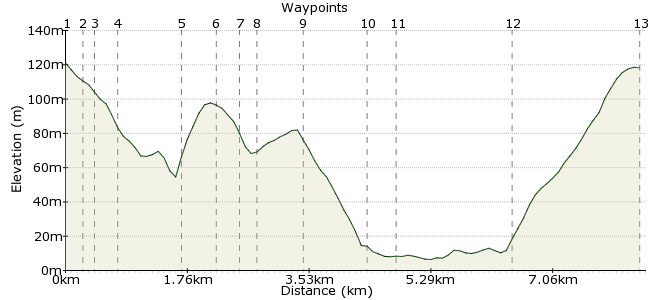
Ascent
173m (567ft)
Descent
175m (574ft)
Max. Elevation
130m (426ft)
Altitude Gain & Loss
348m (1141ft)
Start & End
Holywell
Distance
8.40km
(5.22mi)
(5.22mi)
Duration
~2:45h
Difficulty
Leisurely
Ordnance Survey Map
 1Created by driver 16 on 26 May 2014
'Holy Well' is named after St. Winefride's Well. This is a walk out into the surrounding countryside with views over the Dee Estuary to the Wirral and Mostyn Docks, where they assemble and ship windmills out to the Gwynt-y-Mor (wind of the sea) wind farm. The route incorporates the first and last stages of my 1st walk in Holywell and Greenfield Valley Heritage Park, also on carfreewalks.org.
Walk Functions
Share
Nearby Walks
Holywell and Greenfield Valley Heritage Park
A leisurely, circular walk (woodland) starting in Flintshire, Wales, about 2.90km (1.80 mi) long, duration: ~0:45h.Point of Ayr RSPB reserve
A leisurely, circular walk (coast) starting in Flintshire, Wales, about 4.40km (2.73 mi) long, duration: ~1:15h.Mold walk - Daniel Owen
A leisurely, circular walk (city/town) starting in Flintshire, Wales, about 3.20km (1.99 mi) long, duration: ~0:45h.Walk Map
- $walk->POI array(0)
Waypoints
OS Grid SJ189758
Buses from Rhyl to / from Chester. Cross at the pelican crossing, look up slightly left for the street sign 'High Street' half way up a wall, then walk down to a finger post, waypoint 2.
OS Grid SJ186758
Turn right and follow the road to the underpass. Pass through the Tesco car park to waypoint 3.
About 0.26 km (~0.16 miles) from 
OS Grid SJ186760
Take the path down to a history board, then pass under a bridge to the left-side path towards The Well.
About 0.20 km (~0.12 miles) from 
OS Grid SJ185762
If you wish to visit The Well you can do so from here; if not, carry on to waypoint 4.
About 0.22 km (~0.14 miles) from 
OS Grid SJ190769
Walk through the car park to the main road, then cross to the road directly opposite signed 'Bryn Celyn'. Follow this to a gate on your right, then follow to a new housing estate. Go to the left of the first house to a path with a small stream on the right.
About 0.83 km (~0.52 miles) from 
OS Grid SJ185771
Cross a stile, keeping to the right of the field, and pass a water trough. You will see a suspended plastic drainpipe: duck under it, watching out for the electric fence, then continue through the field to the next stile. Climb over and keep walking, with views over the Dee Estuary to a shipwreck of the Duke of Lancaster and Mostyn Docks.
About 0.46 km (~0.29 miles) from 
OS Grid SJ184775
Climb over the stile, then turn right down a farm track. Where the track bears right, look to your left to see two stiles. Climb over the one on the right.
About 0.39 km (~0.24 miles) from 
OS Grid SJ185776
Climb over and follow the path down to a footbridge. Cross, then climb the stile and turn right. Almost immediately turn left onto a signed path, keeping the fence on your left to waypoint 9.
About 0.19 km (~0.12 miles) from 
OS Grid SJ179778
Cross and turn right onto a farm track. Where the track bears left, go straight ahead to follow the bridleway by a stream down to the main road at Hen Dafarn (Old Tavern), waypoint 10.
About 0.63 km (~0.39 miles) from 
OS Grid SJ186783
At the Happy Ship market area, turn left and cross the road to waypoint 11.
About 0.88 km (~0.55 miles) from 
OS Grid SJ184786
Usually you head down to the Wales Coast Path, but if you're over 5'6", duck under the railway bridge to get close up of the old ship. Here, you usually turn right onto the Wales Coast Path, but due to winter storms it is damaged and closed for repairs at the moment. Instead take the main road to waypoint 12.
About 0.38 km (~0.24 miles) from 
OS Grid SJ196775
This is the entrance to walk up the valley back into town.
About 1.66 km (~1.03 miles) from 
 End of walk
OS Grid SJ188758
Hope you found many interesting features and enjoyed it as much as me.
About 1.83 km (~1.14 miles) from 
