Tour of Ingleborough
A hard walk (mountain (above 600m)) in national park Yorkshire Dales in North Yorkshire, England, about 40.00km (24.85 mi) long with an estimated walking time of about 13:15h (1 overnight stay). It is unsuitable for families with children, prams & pushchairs, wheelchairs.
Elevation Profile
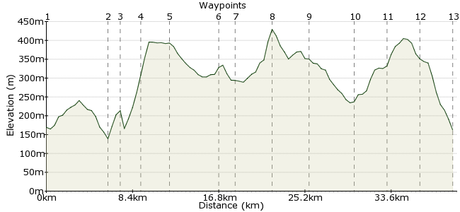
Ascent
510m (1673ft)
Descent
517m (1696ft)
Max. Elevation
430m (1410ft)
Altitude Gain & Loss
1027m (3369ft)
Start & End
Clapham
Distance
40.00km
(24.85mi)
(24.85mi)
Duration
~13:15h
Difficulty
Hard
Ordnance Survey Map
A tour of Ingleborough in the Yorkshire Dales. This is also a good route on a mountain bike. Start and finish at Clapham, which is on bus and train routes.
Walk Functions
Share
Nearby Walks
Clapham to Horton via Crummack Dale
A moderate, linear walk (low hills and fells (below 600m)) starting in North Yorkshire, England, about 11.80km (7.33 mi) long, duration: ~4:15h.The Ingleton Waterfall Walk
A leisurely, circular walk (riverside) starting in West Yorkshire, England, about 5.30km (3.29 mi) long, duration: ~1:45h.Horton in Ribblesdale to Hawes solo, car free
A strenuous, linear walk (mountain (above 600m)) starting in North Yorkshire, England, about 18.60km (11.56 mi) long, duration: ~6:15h.Walk Map
- $walk->POI array(0)
Waypoints
OS Grid SD745693
Start at Clapham, south of Ingleborough. Note the station for Clapham is a little way south of the village.
OS Grid SD697729
Follow the road to Ingleton.
About 6.02 km (~3.74 miles) from 
OS Grid SD707738
A short dog-leg round to the quarry, then head up the western side of Ingleborough.
About 1.32 km (~0.82 miles) from 
OS Grid SD699755
Continue to Twistleton Scar End.
About 1.91 km (~1.19 miles) from 
OS Grid SD719774
Take the bridleway over Scales Moor.
About 2.75 km (~1.71 miles) from 
OS Grid SD757803
At Winterscales, head south after crossing the railway.
About 4.75 km (~2.95 miles) from 
OS Grid SD765792
At Ribblehead, veer northeast along the road.
About 1.35 km (~0.84 miles) from 
OS Grid SD801804
Pick up the Dales Way to Cam Fell. At Cam End, head south.
About 3.77 km (~2.34 miles) from 
OS Grid SD803770
Continue along the Pennine Bridleway to Birkwith Moor.
About 3.44 km (~2.14 miles) from 
OS Grid SD804726
The Pennine Way takes you to Horton in Ribblesdale.
About 4.41 km (~2.74 miles) from 
OS Grid SD782746
Back towards Ingleborough along the road to Gill Garth.
About 2.96 km (~1.84 miles) from 
OS Grid SD762718
Take the bridleway across Long Scar back towards Clapham.
About 3.44 km (~2.14 miles) from 
 Clapham again
OS Grid SD744692
Finish up in Clapham for the train or bus home.
About 3.14 km (~1.95 miles) from 

1 comment... join the discussion!
mac.hawk
Most of the route mentioned in Section 3 is along RoW footpath (NOT bridleway) and if you're mountain biking you should really be carrying your bike between leaving the road to reaching Scar End/Twistleton Hall to save yet another footpath being carved up by irresponsible mountain bikers.