Marsden 7.5 loop
A moderate walk (countryside) in national park Peak District in Kirklees, England, about 11.10km (6.90 mi) long with an estimated walking time of about 3:45h. It is suitable for families with children, but unsuitable for prams & pushchairs, wheelchairs.
Elevation Profile
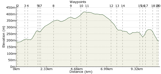
Ascent
268m (879ft)
Descent
286m (938ft)
Max. Elevation
420m (1377ft)
Altitude Gain & Loss
554m (1817ft)
Start & End
Marsden
Distance
11.10km
(6.9mi)
(6.9mi)
Duration
~3:45h
Difficulty
Moderate
Ordnance Survey Maps
A walk taking in canals, moorland, reservoirs, hills and rivers all in one relatively short walk.
Starting at the Riverhead brewery, along the canal to the Standedge tunnel and visitors' centre (the longest canal tunnel in Britain), then a gentle climb up onto moorland for spectacular views over the old woolen mill town of Marsden. Undulating moorland then takes you past Redbrook, Swellands and Black Moss reservoirs before joining up with the Kirklees Way. This takes you alongside Blakely reservoir and then past the beautiful Butterfly reservoir with its dams and weirs. Follow the Kirklees Way back into Marsden and the Riverhead brewery, a great spot for refreshments and great food.
Walk Functions
Share
Nearby Walks
Marden Circular via the Conduits
A moderate, circular walk (low hills and fells (below 600m)) starting in Kirklees, England, about 18.10km (11.25 mi) long, duration: ~6:15h.Marsden to Hedbden Bridge
A strenuous, linear walk (low hills and fells (below 600m)) starting in Kirklees, England, about 23.70km (14.73 mi) long, duration: ~7:45h.Marsden Circular
A moderate, circular walk (low hills and fells (below 600m)) starting in Kirklees, England, about 15.20km (9.44 mi) long, duration: ~5:00h.Walk Map
- $walk->POI array(0)
Waypoints
OS Grid SE046118
Start from Marsden station.
OS Grid SE045117
Immediately before the station turn left onto the canal towpath
About 0.07 km (~0.04 miles) from 
OS Grid SE040119
From the visitors centre bear right and follow the path and steps up to the road - cross over the road and 30 meters on the right, pick up the path and gently ascend up the hills overlooking Marsden.
About 0.57 km (~0.35 miles) from 
OS Grid SE037118
Continue up the path and between the disused farm buildigs
About 0.27 km (~0.17 miles) from 
OS Grid SE040112
Continue between the buildings and follow the track down to a small stream and over a stile
About 0.69 km (~0.43 miles) from 
OS Grid SE040111
Over the stile and stream and continue through the the small copse to the 2nd stile and back onto the track.
About 0.08 km (~0.05 miles) from 
OS Grid SE041110
At the gate bear right up the hill to the buildings then follow the track all the way to the road
About 0.19 km (~0.12 miles) from 
OS Grid SE037101
Cross the road and bearing right, take the steepish path down and over a the stream via a small bridge and up the other side follow the path right across the moorland and with the reservoir to your right take the path to the left - NOT following the path that goes straight on.
About 0.97 km (~0.6 miles) from 
OS Grid SE026094
Take a 90 degree turn left here onto the not so obvious path and follow it gently up and round.
About 1.26 km (~0.78 miles) from 
OS Grid SE030088
Take the path that goes left before the reservoir and then follow it turning right onto the paved path between the two reservoirs
About 0.74 km (~0.46 miles) from 
OS Grid SE033089
Take the path between the two reservoirs and continue bearing left, then right before descending down to the river
About 0.34 km (~0.21 miles) from 
OS Grid SE052089
Cross the river here - normally very narrow but with heavy rainfall take care as it can be a little trickier to cross.
About 1.87 km (~1.16 miles) from 
OS Grid SE053092
Continue up the hill and then at the top take the steep path down to the left, across the wooden bridge and then up the other side onto the broad track (Kirklees Way)
About 0.36 km (~0.22 miles) from 
OS Grid SE054097
Follow the broad way past the Butterfly reservoir and take in the great views of the dam and weir on your right.
About 0.48 km (~0.3 miles) from 
OS Grid SE048107
At the end of the path turn directly right, back on yourself onto Binn road and follow this a few hundred meters before taking the footpath on your left.
(Alternatively you can carry straight on through the town back to the finish at the Riverhead brewery)
About 1.23 km (~0.76 miles) from 
OS Grid SE049107
Take the footpath off to the left and follow it round past some buildings and onto an unpaved road.
About 0.13 km (~0.08 miles) from 
OS Grid SE051107
Take the unpaved road left and continue along the path at the bottom of the moorland hills
About 0.18 km (~0.11 miles) from 
OS Grid SE052112
When the path reaches the farm/factory buildings turn left to join the road and continue along this towards town.
About 0.56 km (~0.35 miles) from 
OS Grid SE050115
Continue straight on bearing slightly left along Carrs Road then continue straight on along Peel street straight ahead and to the finish at the Riverhead brewery
About 0.29 km (~0.18 miles) from 
 Marsden again
OS Grid SE048116
Finish back at Marsden station for the train home.
About 0.18 km (~0.11 miles) from 
