Rise Hill from Dent
A moderate walk (low hills and fells (below 600m)) in national park Yorkshire Dales in Cumbria, England, about 16.50km (10.25 mi) long with an estimated walking time of about 6:15h. It is suitable for families with children, but unsuitable for prams & pushchairs, wheelchairs.
Elevation Profile
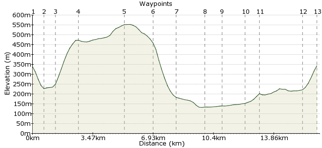
Ascent
535m (1755ft)
Descent
531m (1742ft)
Max. Elevation
560m (1837ft)
Altitude Gain & Loss
1066m (3497ft)
Start & End
Dent station
Distance
16.50km
(10.25mi)
(10.25mi)
Duration
~6:15h
Difficulty
Moderate
Ordnance Survey Map
This walk climbs over Rise Hill, above Dentdale, and then returns via the dale. The plus points? A fantastic view of one of Yorkshire's pleasantest dales, and great pubs in Dent village - make sure you try one of the local ales! The only downside is the final slog back up to Dent station from Cowgill (there are occasional buses at weekends and bank holidays).
Walk Functions
Share
Nearby Walks
Dent to Ribblehead via Great Knoutberry Hill
A moderate, linear walk (mountain (above 600m)) starting in Cumbria, England, about 15.00km (9.32 mi) long, duration: ~6:00h.Whernside - one of Yorkshire's Big Three
A moderate, linear walk (mountain (above 600m)) starting in North Yorkshire, England, about 14.50km (9.01 mi) long, duration: ~5:45h.Garsdale circular to Great Shunner Fell summit
A strenuous, circular walk (mountain (above 600m)) starting in Cumbria, England, about 22.30km (13.86 mi) long, duration: ~8:45h.Walk Map
- $walk->POI array(0)
Waypoints
OS Grid SD763874
Start at Dent station and walk downhill to the station (there are weekend buses to Dent as well, connecting to Kendal and Sedbergh).
OS Grid SD760869
You need to drop into Cowgill village before heading to the hill (why is it not called Cowgill station?)
About 0.62 km (~0.39 miles) from 
OS Grid SD755872
Take the second turn right up the valley, which connects to a bridleway leading uphill.
About 0.61 km (~0.38 miles) from 
OS Grid SD748883
It's a very steep climb up onto the hill. For a gentler ascent, follow Cowgill Beck around to the end of the hill.
About 1.28 km (~0.8 miles) from 
OS Grid SD723885
Continue along the line of high ground to the summit of Rise Hill.
About 2.60 km (~1.62 miles) from 
OS Grid SD708891
Continue heading west from the top. Aim for the hamlet of Rawridding, and pick up the footpath above it.
About 1.58 km (~0.98 miles) from 
OS Grid SD697884
The path circles the base of Rise Hill, leading into Dentdale.
About 1.25 km (~0.78 miles) from 
OS Grid SD707871
Well worth popping into Dent for a pint in one of the village's pubs.
About 1.62 km (~1.01 miles) from 
 Riverside path
OS Grid SD715867
Follow the riverside path along Dentdale.
About 0.91 km (~0.57 miles) from 
OS Grid SD735859
Then back to the south side again along the dale.
About 0.89 km (~0.55 miles) from 
OS Grid SD756869
Return to Cowgill near the end of the dale.
About 2.31 km (~1.44 miles) from 
 Back to Dent station
OS Grid SD764874
Here comes the killer - the final climb back up to Dent station will be painful after the long walk, but the scenery on the train back home will be your reward.
About 0.85 km (~0.53 miles) from 
