Marble Hill to Bushy Park
A moderate walk (riverside) starting and finishing in City of London, England, about 12.20km (7.58 mi) long with an estimated walking time of about 3:30h. It is suitable for families with children, but unsuitable for prams & pushchairs, wheelchairs.
Elevation Profile
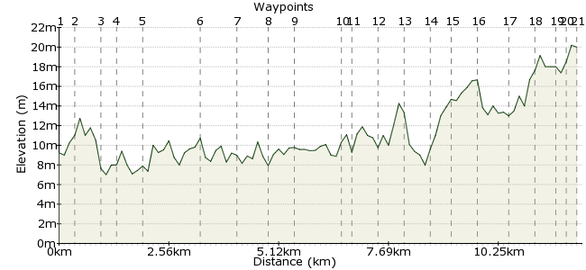
Ascent
25m (82ft)
Descent
15m (49ft)
Max. Elevation
30m (98ft)
Altitude Gain & Loss
40m (131ft)
Start
Twickenham
End
Hampton Hill
Distance
12.20km
(7.58mi)
(7.58mi)
Duration
~3:30h
Difficulty
Moderate
Ordnance Survey Map
 3Created by John Walker on 07 Aug 2014
A riverside and park walk through SW London suburbs, with lots of scenery and history. There's Marble Hill House, Ham House, Bushy House and the Cascade a well as parakeets and red deer. You rarely need to stray onto roads. There is easy access to both ends of the walk by frequent public transport.
Walk Functions
Share
Nearby Walks
Richmond & St. Margarets Loop
A leisurely, circular walk (riverside) starting in City of London, England, about 6.70km (4.16 mi) long, duration: ~1:30h.The River Crane walk
A leisurely, linear walk (riverside) starting in Surrey, England, about 4.40km (2.73 mi) long, duration: ~1:15h.Twickenham to Putney
A moderate, linear walk (riverside) starting in Surrey, England, about 12.20km (7.58 mi) long, duration: ~3:30h.Walk Map
- $walk->POI array(0)
Waypoints
OS Grid TQ166740
The walk starts at the entrance to Marble Hill Park (get there from St. Margarets station or by bus (33, R70, R68, H22 etc.) from Richmond).
OS Grid TQ169738
). Follow the path towards Marble Hill House then turn left to pass on the river-side of the house. Turn right towards the river at the next junction.
About 0.36 km (~0.22 miles) from 
OS Grid TQ174734
Coming out of the park onto the towpath go right along it for about 0.5km until you reach a sign for Hammerton's Ferry (hours 10.00 to 18.00 at weekends throughout the year and daily during summer).
About 0.62 km (~0.39 miles) from 
OS Grid TQ172733
Cross the ferry to the towpath on the Ham side of the Thames, turning right along the tow path past Ham House. This is a National Trust property with a great garden and a nice café.
About 0.29 km (~0.18 miles) from 
OS Grid TQ166730
The path follows close to the river past Eel Pie Island and the former gravel pit now used by Thames Young Mariners.
About 0.59 km (~0.37 miles) from 
OS Grid TQ164718
Teddington Lock appears next. This is the limit of the tidal Thames. A path over a footbridge leads to public toilets then on towards Teddington which has plenty of refreshments opportunities, bus stops and a train station. There is a plan to harness the considerable flow of water over Teddington weir to generate renewable electricity.
About 1.30 km (~0.81 miles) from 
OS Grid TQ171713
The towpath continues alongside Ham Common and then opposite another small island (Steven's Eyot) before reaching the Lower Ham Rd.
About 0.86 km (~0.53 miles) from 
OS Grid TQ178709
Follow this road alongside the river for 0.5km before leaving it to stay close to the river past the Boaters pub.
About 0.78 km (~0.48 miles) from 
OS Grid TQ179704
From here there is a tree-lined section through Canford Park, then under the railway line, past another pub and the back of John Lewis.
About 0.52 km (~0.32 miles) from 
OS Grid TQ177694
Take the tunnel under Kingston Bridge and turn right up the steps on the far side to come out on the up-stream side of the bridge. Cross over to the Hampton Wick side of the river and bear left at the roundabout.
About 1.00 km (~0.62 miles) from 
OS Grid TQ175693
Cross Hampton Court Rd. at the traffic lights and head a short distance up Church Grove then turn left through wrought iron gates into a tree-lined path with allotments on the right.
About 0.26 km (~0.16 miles) from 
OS Grid TQ169693
At the end of this path go through a gate into Bushy Park. At the further corner of the cricket pitch turn right diagonally towards a clump of trees, passing just to the right of them to follow the left bank of a small lake. This becomes a small channel linking to another lake.
About 0.54 km (~0.34 miles) from 
OS Grid TQ164696
Cross the bridge to follow the right hand bank of this one and then cross two more footbridges to the left, leading into a car park.
About 0.60 km (~0.37 miles) from 
OS Grid TQ160694
Cross the car park and exit from the right hand corner, following a metalled path signposted to the Pheasantry. This is a new (2009) café inside one of the Woodland Gardens and serves hot and cold refreshments.
About 0.51 km (~0.32 miles) from 
OS Grid TQ157696
On leaving here retrace your steps towards the Woodland Garden gate but turn right just before it and go straight ahead through the Woodland Garden beside ponds with lots of ducks. In spring and early summer this area is full of azaleas.
About 0.41 km (~0.25 miles) from 
OS Grid TQ151696
Exit through a gate and turn right then left to follow outside the perimeter fence of another woodland arden. This path bears right after 200 metres, now going north. Keep straight on in this direction, ignoring the metalled path which heads to the right, towards NPL and Bushy House.
About 0.59 km (~0.37 miles) from 
OS Grid TQ150702
You will shortly see signs to the Water Gardens and Cascade close to Upper Lodge.
About 0.67 km (~0.42 miles) from 
OS Grid TQ144705
When you have walked around the upper and lower ponds and visited the Brew House leave by the same gate but pass in front of Upper Lodge, turning left onto the metalled path.
About 0.68 km (~0.42 miles) from 
OS Grid TQ147706
Turn left again to go along the backs of Upper Lodge and the mysterious Rotunda building, before turning right towards the edge of a cricket pitch.
About 0.32 km (~0.2 miles) from 
OS Grid TQ144707
Follow the boundary line going right, then left, to arrive at the Hampton Hill gate of Bushy Park.
About 0.27 km (~0.17 miles) from 
 Hampton Hill
OS Grid TQ143709
Exit and straight ahead is Hampton Hill High St. Cross the road to the bus stop where R70, R68 or 267 (weekends only) buses will take you to Twickenham or St. Margarets.
About 0.25 km (~0.16 miles) from 
