A run from Holyhead to Holyhead along the coast
A moderate walk (coast) in Isle of Anglesey, Wales, about 11.60km (7.21 mi) long with an estimated walking time of about 3:45h. It is unsuitable for families with children, prams & pushchairs, wheelchairs.
Elevation Profile
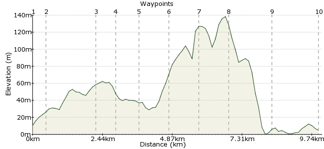
Ascent
158m (518ft)
Descent
164m (538ft)
Max. Elevation
140m (459ft)
Altitude Gain & Loss
322m (1056ft)
Start & End
Holyhead centre
Distance
11.60km
(7.21mi)
(7.21mi)
Duration
~3:45h
Difficulty
Moderate
Ordnance Survey Map
 Created by roygo on 30 Aug 2014
We wanted to run from Holyhead to Holyhead and enjoy the views of the coast path. Go along the South and North Stacks and admire the stunning views !
Walk Functions
Share
Nearby Walks
Holyhead
A moderate, circular walk (coast) starting in Isle of Anglesey, Wales, about 11.10km (6.90 mi) long, duration: ~3:30h.Anglesey Coastal Path
A hard, walk (coast) starting in Isle of Anglesey, Wales, about 125.70km (78.11 mi) long, duration: ~38:15h.Rhosneigr and Llyn Maelog
A leisurely, circular walk (coast) starting in Isle of Anglesey, Wales, about 8.50km (5.28 mi) long, duration: ~2:15h.Walk Map
- $walk->POI array(0)
Waypoints
OS Grid SH246821
Go fast enough to get there, but slow enough to see things.
OS Grid SH241819
From 1 to 2 to get along.
About 0.57 km (~0.35 miles) from 
 Towards the Coast Path
OS Grid SH225806
Head to Penrhosfeilw, then turn right
About 1.98 km (~1.23 miles) from 
OS Grid SH216815
Yes, we can smell the salt water!
About 0.87 km (~0.54 miles) from 
OS Grid SH205822
Beautiful views, stunning moments.
About 1.29 km (~0.8 miles) from 
OS Grid SH215828
It's lovely to run along the coast!
About 1.18 km (~0.73 miles) from 
OS Grid SH215839
Oh yes, we're almost there!
About 1.07 km (~0.66 miles) from 
OS Grid SH233839
It's a shame, already heading back towards Holyhead.
About 1.79 km (~1.11 miles) from 
 The last station
OS Grid SH249829
Back to number 1! The end of a marvellous route.
About 1.85 km (~1.15 miles) from 

1 comment... join the discussion!
driver 16
Also see my walk and photos from it at Flickr, TAG CARFREEWALKS, screen I D driver 16, album HOLYHEAD.