Fan Fawr from Storey Arms
A moderate walk (mountain (above 600m)) in national park Brecon Beacons in Powys, Wales, about 19.00km (11.81 mi) long with an estimated walking time of about 7:15h. It is unsuitable for families with children, prams & pushchairs, wheelchairs.
Elevation Profile
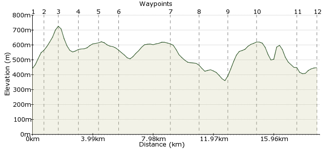
Ascent
561m (1840ft)
Descent
556m (1824ft)
Max. Elevation
730m (2395ft)
Altitude Gain & Loss
1117m (3664ft)
Start & End
Storey Arms bus stop
Distance
19.00km
(11.81mi)
(11.81mi)
Duration
~7:15h
Difficulty
Moderate
Ordnance Survey Map
From Storey Arms, you head east up to the Brecon Beacons, right? Well, that's a fine walk, but for something a little more serene, turn away from the crowds and head west to Fan Fawr and Fan Llia. The hills are just as fine - although not quite as high - and you may well get to wander among them by yourself.
Buses between Brecon and Merthyr Tydfil stop at Storey Arms (not many on Sundays, unfortunately).
Walk Functions
Share
Nearby Walks
Pen Y Fan Horseshoe
A moderate, linear walk (mountain (above 600m)) starting in Powys, Wales, about 16.20km (10.07 mi) long, duration: ~6:15h.The Brecon Beacons' big three from Storey Arms
A moderate, circular walk (mountain (above 600m)) starting in Powys, Wales, about 15.10km (9.38 mi) long, duration: ~6:30h.Circuit in Central Beacons, including Fan y Big
A moderate, walk (mountain (above 600m)) starting in Powys, Wales, about 10.60km (6.59 mi) long, duration: ~4:00h.Walk Map
- $walk->POI array(0)
Waypoints
OS Grid SN981203
Take the bus to Storey Arms.
OS Grid SN976196
Head up the steep slope southwest of the car park towards Fan Fawr.
About 0.81 km (~0.5 miles) from 
OS Grid SN968192
Rarely is a peak so quickly or so steeply gained. It's a rousing start to the day.
About 0.89 km (~0.55 miles) from 
OS Grid SN965206
Head north-northwest from the summit, across the boggy saddle of Craig y Fro.
About 1.37 km (~0.85 miles) from 
OS Grid SN963217
Continue to the edge of Craig Cerrig-gleisiad, one of the distinctive steep slopes that define this corner of Wales.
About 1.13 km (~0.7 miles) from 
OS Grid SN950212
Pick up the Beacons Way heading southwest along the ridge.
About 1.36 km (~0.85 miles) from 
OS Grid SN935181
Head along Fan Dringarth to Fan Llia, with wonderful views south across the Welsh valleys.
About 3.40 km (~2.11 miles) from 
OS Grid SN932200
Head off the northern flank to the track running along the valley.
About 1.85 km (~1.15 miles) from 
OS Grid SN940218
The track contours along the lower slopes until you reach Nant Cwm-du. Just beyond the valley, veer right up the sharp slope.
About 2.00 km (~1.24 miles) from 
OS Grid SN956227
One last uphill stomp to the day's final summit, Fan Frynych. From here, pick up the ridge back round to Craig Cerrig-gleisiad.
About 1.86 km (~1.16 miles) from 
OS Grid SN971206
Return via the Beacons Way towards Storey Arms once more.
About 2.53 km (~1.57 miles) from 
 Bus stop
OS Grid SN984202
Return to Storey Arms for the bus back home.
About 1.35 km (~0.84 miles) from 

1 comment... join the discussion!
Hillsider
Looks good on the map, but on the ground, not so much. The section between Fan Llia and the start of the climb up Fan Frynach is a long tedious slog down across rough ground, followed by walking along the track which is seriously eroded and with lots of loose rocks and stones. Nant Cwm-Du is very pretty though.