Settle circular water walk
A moderate walk (countryside) in national park Yorkshire Dales in North Yorkshire, England, about 9.80km (6.09 mi) long with an estimated walking time of about 3:15h. It is suitable for families with children, but unsuitable for prams & pushchairs, wheelchairs.
Elevation Profile
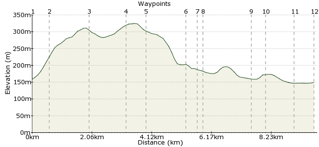
Ascent
175m (574ft)
Descent
185m (606ft)
Max. Elevation
330m (1082ft)
Altitude Gain & Loss
360m (1180ft)
Start & End
Settle Railway Station
Distance
9.80km
(6.09mi)
(6.09mi)
Duration
~3:15h
Difficulty
Moderate
Ordnance Survey Map
 2Created by mac.hawk on 29 Nov 2014
Approx 8 mile walk taking in two waterfalls of quite different variety. Initially some modest up hill walking with a decent stretch of fairly flat riverside walking (that can be muddy at times).
Visits St Peter's church in Stainforth with it's wonderful Millenium Window.
All amenities available in Settle.
Public toilets available in Stainforth along with the Craven Heifer pub.
Walk Functions
Share
Nearby Walks
Settle to Grassington via Malham
A moderate, linear walk (low hills and fells (below 600m)) starting in North Yorkshire, England, about 20.80km (12.92 mi) long, duration: ~7:45h.Settle to Horton via Stainforth & Pen Y Ghent
A moderate, linear walk (mountain (above 600m)) starting in North Yorkshire, England, about 17.80km (11.06 mi) long, duration: ~7:00h.Giggleswick/Settle Circular
A moderate, circular walk (countryside) starting in North Yorkshire, England, about 12.70km (7.89 mi) long, duration: ~4:00h.Walk Map
- $walk->POI array(0)
Waypoints
OS Grid SD819637
From the railway station take the access road to meet the main road and turn right. Reach the T-junction traffic lights and turn left to reach Settle Market Square.
OS Grid SD822641
Pass the Co-Op on your left and take Constitution Hill steeply uphill and at the top veer left. At the fork take the track leading right, continuing uphill and pass through a five bar gate.
About 0.51 km (~0.32 miles) from 
OS Grid SD829653
Initially follow the wall on the left to soon pass into an open field and follow the path as it continues to rise NE (diagonally right) to reach the road SW of Cow Close.
About 1.34 km (~0.83 miles) from 
OS Grid SD829665
Follow the road for a little over half a mile, cross a cattle grid then turn left down the access road to the farms at Windskill. Directly before Upper Windskill Farm turn right to follow the wall.
About 1.21 km (~0.75 miles) from 
OS Grid SD832670
Follow the wall on your left to soon reach a track. Turn left through the gate after which a second gate leads to a gate on the right & an access path that leads downhill to Catrigg Force waterfall.
About 0.63 km (~0.39 miles) from 
OS Grid SD820673
Return back to the access gate, and turn right along the track to descend quite steeply into Stainforth. Take time to visit St Peter's church and the wonderful Millemium Window.
About 1.24 km (~0.77 miles) from 
OS Grid SD817672
Leave the church & turn right briefly, then right again to reach the B6479 Settle-Horton road (toilets & picnic area nearby). Turn right for 300yds then left downhill to the old packhorse bridge.
About 0.35 km (~0.22 miles) from 
OS Grid SD817671
Take the old packhorse bridge over the river, once over take a stile immediately on the left to follow the river 100 yards downstream to the Stainforth Force waterfalls.
About 0.12 km (~0.07 miles) from 
OS Grid SD817654
Simply follow the RoW footpath that follows the River Ribble on your left for one and a half miles to reach the weir and a footbridge over the river.
About 1.70 km (~1.06 miles) from 
OS Grid SD814650
Turn right up a walled track to reach Stackhouse. Upon reaching the road turn left for 350 yards and take the RoW footpath, adjacent the 5 bar gate on the left, diagonally right across the field.
About 0.47 km (~0.29 miles) from 
OS Grid SD816640
At the field corner the RoW follows the river again, passes through the center of a wide field (towards the playing fields) to reach a walled track that leads initially left then right to reach Settle Bridge.
About 1.00 km (~0.62 miles) from 
 Settle railway station
OS Grid SD816634
Cross Settle Bridge (Grade 2 listed building) and at the crossroads carry on directly ahead to enter Settle and reach the Market Square once again. Retrace your steps back to the railway station.
About 0.66 km (~0.41 miles) from 
