Hebden Bridge Circular via Stoodley Pike
A moderate walk (countryside) in West Yorkshire, England, about 9.40km (5.84 mi) long with an estimated walking time of about 3:30h. It is suitable for families with children, but unsuitable for prams & pushchairs, wheelchairs.
Elevation Profile
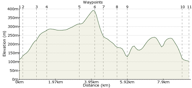
Ascent
278m (912ft)
Descent
288m (944ft)
Max. Elevation
400m (1312ft)
Altitude Gain & Loss
566m (1856ft)
Start & End
Hebden Bridge Railway Station
Distance
9.40km
(5.84mi)
(5.84mi)
Duration
~3:30h
Difficulty
Moderate
Ordnance Survey Map

Walk Functions
Share
Nearby Walks
Hebden Bridge, Crimsworth Dean & Hebden Dale
A moderate, circular walk (countryside) starting in West Yorkshire, England, about 16.00km (9.94 mi) long, duration: ~5:15h.Hebden Bridge Birthday Walk
A moderate, circular walk (countryside) starting in West Yorkshire, England, about 12.40km (7.71 mi) long, duration: ~4:15h.Todmorden to Hebden Bridge
A moderate, linear walk (low hills and fells (below 600m)) starting in West Yorkshire, England, about 11.20km (6.96 mi) long, duration: ~4:00h.Walk Map
- $walk->POI array(0)
Waypoints
OS Grid SD995268
Exit the railway station building and turn immediately right down steps and then right again to pass under the railway bridge. After 100 yards turn right behind housing along a waymarked path.
OS Grid SD995266
Follow the path that rises the edge of the wood, keep rising beyond two sets of cross tracks until the main track turns sharp left. At this point enter Fairfield wood and head diagonally left.
About 0.16 km (~0.1 miles) from 
OS Grid SD988268
Head for the TV mast & exit the wood. Directly cross the road & continue rising the next five fields to reach a wide gate & tarmac road, now turn left. Follow the road to the next junction & turn right.
About 0.75 km (~0.47 miles) from 
OS Grid SD987262
Follow Kilnshaw Lane for a little over a mile passing Erringden Grange & just after passing the farm at Swillington turn left along the waymarked path that rises the hill diagonally left.
About 0.59 km (~0.37 miles) from 
OS Grid SD980247
Pass through a (current) gap in the wall ahead, turn right to pass through a gate and take the wide track that heads towards Stoodley Pike.
About 1.64 km (~1.02 miles) from 
OS Grid SD973242
You can go up to the balcony for fine views of the area, although the stairs are unlit so take a small torch with you to make life easier.
From the Pike take the path that heads west steeply downhill.
About 0.88 km (~0.55 miles) from 
OS Grid SD968242
Cross the Pennine Bridleway that is London Road and follow a walled track downhill to reach Stoodley Grange. At the T junction turn right to pass the former Fielden Hospital on the right.
About 0.50 km (~0.31 miles) from 
OS Grid SD967248
Follow the track for less than 1/2 mile and at the house ahead a path on the left leads downhill to the woodland. Ford the stream and turn left and take the wide track downhill towards the canal.
About 0.68 km (~0.42 miles) from 
OS Grid SD964253
Upon reaching the canal simply turn right & follow the canal towpath for a couple of miles or so to reach Hebden Bridge itself.
About 0.56 km (~0.35 miles) from 
OS Grid SD989271
You can leave the towpath to visit the town at Hebble End Bridge.
To return to the station go through the memorial gardens (near the Picture House) and cross the canal by the bridge and head left.
About 2.99 km (~1.86 miles) from 
 Calder Holmes
OS Grid SD992270
Upon reaching the football field head towards the far right of the park (just follow the path heading right). Exit the park onto a road & go right over the river to reach the railway station.
About 0.33 km (~0.21 miles) from 
