An Eskdale ramble
A leisurely walk (riverside) in national park Lake District in Cumbria, England, about 4.10km (2.55 mi) long with an estimated walking time of about 1:15h. It is suitable for families with children, but unsuitable for prams & pushchairs, wheelchairs.
Elevation Profile
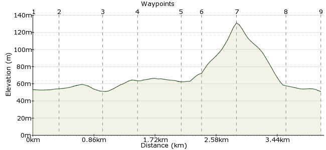
Ascent
84m (275ft)
Descent
86m (282ft)
Max. Elevation
140m (459ft)
Altitude Gain & Loss
170m (557ft)
Start & End
Dalegarth station
Distance
4.10km
(2.55mi)
(2.55mi)
Duration
~1:15h
Difficulty
Leisurely
Ordnance Survey Map
The Ravenglass & Eskdale railway is a popular attraction in the Western Fells. This walk is a great add-on to the day out, exploring the countryside around Dalegarth deep in Eskdale.
The railway is not cheap, but it's well worth a splurge as it's a wonderful journey. There is a pub at Dalegarth as well. Times and fares can be found here:
http://ravenglass-railway.co.uk/timetables/
Walk Functions
Share
Nearby Walks
A three-day Lake District walk
A hard, linear walk (mountain (above 600m)) starting in Cumbria, England, about 37.60km (23.36 mi) long, duration: ~18:15h.Muncaster Fell and Glannoventa Fort
A moderate, circular walk (low hills and fells (below 600m)) starting in Cumbria, England, about 14.50km (9.01 mi) long, duration: ~4:15h.Wetherlam
A moderate, linear walk (mountain (above 600m)) starting in Cumbria, England, about 11.30km (7.02 mi) long, duration: ~5:15h.Walk Map
- $walk->POI array(0)
Waypoints
OS Grid NY172007
Take the train into Eskdale from Ravenglass. Dalegarth is the final stop.
OS Grid NY175008
Walk along the road to the Brook House Inn and take the lane opposite.
About 0.35 km (~0.22 miles) from 
OS Grid NY176002
Follow the lane to St Catherine's church on the River Esk. Follow the river heading east.
About 0.58 km (~0.36 miles) from 
OS Grid NY180001
Look for the footbridge near Gill Force and cross over the Esk. Then turn left and follow the path until you reach a wall, then up onto the Eskdale Bridleway.
About 0.42 km (~0.26 miles) from 
OS Grid NY175000
The bridleway continues into a woodland.
About 0.51 km (~0.32 miles) from 
OS Grid NY172000
At the far edge of the woods, across the stream, you will find a signposted route up to Stanley Force waterfall.
About 0.23 km (~0.14 miles) from 
OS Grid SD173996
Take care looking over the viewpoint to the falls - it's a very long drop! Then retrace your steps back down the path.
About 0.44 km (~0.27 miles) from 
OS Grid NY170001
Take the path past Dalegarth Hall, which joins the road through the dale.
About 0.64 km (~0.4 miles) from 
 The road
OS Grid NY171005
Turn right to Dalegarth station or right to Beckfoot station.
About 0.41 km (~0.25 miles) from 
