Port Soderick to Douglas along Marine Drive
A leisurely walk (coast) starting and finishing in Isle of Man, Isle of Man, about 7.10km (4.41 mi) long with an estimated walking time of about 2:00h. It is suitable for families with children, prams & pushchairs, wheelchairs.
Elevation Profile
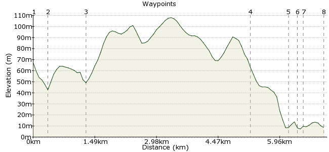
Ascent
32m (104ft)
Descent
90m (295ft)
Max. Elevation
110m (360ft)
Altitude Gain & Loss
122m (399ft)
Start
Port Soderick railway station.
End
Douglas
Distance
7.10km
(4.41mi)
(4.41mi)
Duration
~2:00h
Difficulty
Leisurely
Ordnance Survey Map
 2Created by mac.hawk on 19 Dec 2014
A 5 mile, tarmac, coastal walk (mainly) along a road that's no longer open to motorised through traffic (Marine Drive). Initial descent from the railway station a little steep so care needed for wheelchair users. Train services to Port Soderick in 2015 are 5th March to 8th November.
Walk Functions
Share
Nearby Walks
Southern half of The Millennium Way
A moderate, linear walk (countryside) starting in Isle of Man, England, about 15.90km (9.88 mi) long, duration: ~4:45h.Castletown, Silverdale Glen and coastal path
A moderate, circular walk (riverside) starting in Isle of Man, Isle of Man, about 11.40km (7.08 mi) long, duration: ~3:15h.Castletown & the Langness Peninsular
A moderate, circular walk (coast) starting in Isle of Man, Isle of Man, about 10.60km (6.59 mi) long, duration: ~3:00h.Walk Map
- $walk->POI array(0)
Waypoints
OS Grid SC341730
Exit the railway station & turn right under the railway bridge. Follow the road downhill to the road junction. To visit the shore carry on ahead downhill otherwise turn left & follow the A37 road.
OS Grid SC343728
Follow the A37 to the junction just south of Keristal.
About 0.32 km (~0.2 miles) from 
OS Grid SC351731
At the junction go right and take the clifftop road for approx 3 miles to reach Douglas Head.
About 0.85 km (~0.53 miles) from 
OS Grid SC387746
There's a fantastic view across Douglas bay from here. Carry on downhill along the road to reach a roundabout.
About 3.91 km (~2.43 miles) from 
OS Grid SC380751
At the roundabout turn right to reach a second roundabout.
About 0.88 km (~0.55 miles) from 
OS Grid SC382751
At the second roundabout turn left and take the bridge over the river,
About 0.19 km (~0.12 miles) from 
OS Grid SC381753
Immediately beyond the car park directly ahead is the Lord Street bus terminus.
About 0.19 km (~0.12 miles) from 
 Douglas Railway Station
OS Grid SC376752
To end the walk at Douglas railway station, once over the river turn left and follow the river to the road junction where you'll find the station on the right. Walk is approx 5 miles long.
About 0.50 km (~0.31 miles) from 
