Two Hemispheres Walk
A moderate walk (low hills and fells (below 600m)) in national park South Downs starting and finishing in East Sussex, England, about 9.90km (6.15 mi) long with an estimated walking time of about 3:15h. It is suitable for families with children, but unsuitable for prams & pushchairs, wheelchairs.
Elevation Profile
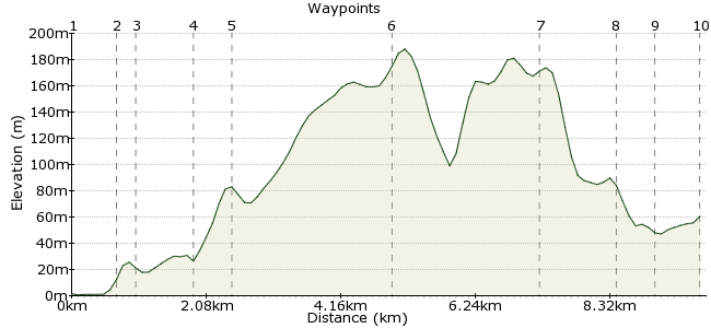
Ascent
194m (636ft)
Descent
135m (442ft)
Max. Elevation
190m (623ft)
Altitude Gain & Loss
329m (1078ft)
Start
Southease
Distance
9.90km
(6.15mi)
(6.15mi)
Duration
~3:15h
Difficulty
Moderate
Ordnance Survey Map
 3Created by John Walker on 29 Dec 2014
This stage of the South Downs Way, going west, starts at tiny Southease train station. The train from Clapham Junction to Lewes and then to Southease proves to be a quick (about 1 hour) route to reach the start of this relatively gentle walk. The stage ends at a bus stop on the A27 from which buses to Lewes train station are quite frequent.
Walk Functions
Share
Nearby Walks
Downs and Out
A leisurely, linear walk (countryside) starting in East Sussex, England, about 6.90km (4.29 mi) long, duration: ~2:15h.Bishopstone to Berwick Wanderer
A moderate, linear walk (countryside) starting in East Sussex, England, about 10.20km (6.34 mi) long, duration: ~3:15h.Ringmer - Saxon Cross - Lewes
A leisurely, linear walk (low hills and fells (below 600m)) starting in East Sussex, England, about 4.70km (2.92 mi) long, duration: ~1:30h.Walk Map
- $walk->POI array(0)
Waypoints
OS Grid TQ430055
The walk begins on a metalled road from the Southease station level crossing, heads to a narrow bridge over the River Ouse (looking full when we were there, after the wettest June on record). This is just downstream from Monks House and close to where Virginia Woolf drowned.
OS Grid TQ423052
The path continues to the minute but perfectly formed village of Southease (population 50), just a thatched cottage or two and a large house on a village green plus a beautiful round-towered Saxon church. No pub, though. We saw a kestrel here, trying hard to hover in a gale force west wind.
About 0.75 km (~0.47 miles) from 
OS Grid TQ421054
Continuing ahead at a cross roads, the SDW takes a well signed right turn through a field gate onto a grassy track which winds downhill to the bottom of a valley, then going left along a metalled track heading up the valley. In high summer wheat and barley fields line one side, poppies and mallow growing at the edge. Solitary swifts were swooping low over the rippling barley stalks.
About 0.29 km (~0.18 miles) from 
OS Grid TQ413049
At the head of the valley, just before some farm buildings, the path turns right uphill, then right again, heading out onto chalk downland grass. This is Mill Hill.
About 0.90 km (~0.56 miles) from 
OS Grid TQ411054
At the brow of the hill the path passes between two house gates, along a tunnel of trees, to emerge on an upward sweep of downs, climbing steadily across Front Hill then Iford Hill, finally peaking at 192 metres. On the stretch you cross the invisible meridian line, from eastern to western hemispheres. To locate the transition you can check when your gps longitude reading goes from positive to negative.
About 0.55 km (~0.34 miles) from 
OS Grid TQ389065
Where the concrete path turns left the SDW turns right then, shortly after, left to follow the scarp edge of Swanborough Hill. Here there are round barrows and a fenced-off dew pond, quite dry when we passed, in spite of days of heavy rain. Looking back you can see the sea at Newhaven with the Seven Sisters beyond. Nearer is the coast at Saltdean. Although Brighton is not far it is quite invisible, only the village of Kingston, at the foot of the hill, and Lewes, at the head of the Ouse valley can be seen. The gleaming white Ashcombe Mill stands out, the conversion to a working windmill not yet complete in 2012. Then ahead the garish silver shape of the Amex football stadium intrudes. On the gale-swept ridge there were skylarks but few flowers, just a few cowslips and buttercups.
About 2.49 km (~1.55 miles) from 
OS Grid TQ368074
At the gas pressure reducing plant (its wind turbine racing) we followed the SDW to the right downhill, past a small wood which gives shelter for orchids, meadowsweet and poppies thriving on a bank.
About 2.24 km (~1.39 miles) from 
OS Grid TQ371086
Alongside a field of rape the path heads down to enter a small wood leading to the railway line.
About 1.19 km (~0.74 miles) from 
OS Grid TQ373091
A tunnel takes the path under then it goes left, parallel to the railway and the A27 main road. This was the only muddy section of the whole path, surprising in view of the massive amounts of recent rain.
About 0.54 km (~0.34 miles) from 
 Bus stop for Lewes
OS Grid TQ367091
Emerging onto a short length of tarmac road the path crosses the A27 on a bridge, going right to reach Housedean Farm. Just beyond, on a slip road of the A27 is a bus stop where we caught a #29 bus back to Lewes. The station has a nice buffet where we waited for the Clapham Junction train.
About 0.61 km (~0.38 miles) from 

1 comment... join the discussion!
Timwoods
This is one of my favourite walks in Sussex, possibly the UK. A fine section of the South Downs. Well worth heading into Lewes for a pint if time allows, it has a host of wonderful pubs. Nearest to the station is the Kings Head. Turn left out of the station and at the roundabout, turn right (i.e. away from the football ground) and it's a few meters down on the right.