Addingham to Ilkley over Beamsley Beacon
A moderate walk (countryside) starting and finishing in Bradford, England, about 15.80km (9.82 mi) long with an estimated walking time of about 5:30h. It is unsuitable for families with children, prams & pushchairs, wheelchairs.
Elevation Profile
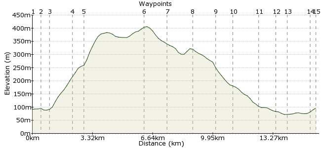
Ascent
338m (1108ft)
Descent
333m (1092ft)
Max. Elevation
410m (1345ft)
Altitude Gain & Loss
671m (2200ft)
Start
Addingham
End
Ilkley
Distance
15.80km
(9.82mi)
(9.82mi)
Duration
~5:30h
Difficulty
Moderate
 2Created by mac.hawk on 04 Jan 2015
A not too strenuous 10 1/2 mile West Yorkshire ramble along road, track and moor. Can be very boggy between (7) & (8) in the 'wet' season. Regular bus service from Leeds, Ilkley, Keighley & Skipton to Addingham. Trains to Leeds or Bradford and buses to all over the place from Ilkley.
Walk Functions
Share
Nearby Walks
Ilkley Amble
A leisurely, circular walk (countryside) starting in Bradford, England, about 9.10km (5.65 mi) long, duration: ~2:45h.Bolton Abbey Circular via Simon's Seat
A moderate, circular walk (low hills and fells (below 600m)) starting in North Yorkshire, England, about 15.20km (9.44 mi) long, duration: ~5:15h.Rombalds Moor
A moderate, linear walk (low hills and fells (below 600m)) starting in Bradford, England, about 12.50km (7.77 mi) long, duration: ~4:15h.Walk Map
- $walk->POI array(0)
Waypoints
OS Grid SE084494
Alight the bus at the junction with Church Street and follow Church Street to pass St Peter's Church. Follow the road at it veers right to become North Street.
OS Grid SE083499
As the road rounds the next bend take a path on the right to the footbridge over the river, cross & carry on to pass West Hall farm. On reaching the road carry on ahead to the bend in the road.
About 0.50 km (~0.31 miles) from 
OS Grid SE086503
Follow a way marked bridleway that rises the hill ahead. Beyond the single tree it veers left into an enclosed lane. Continue uphill to reach the road near Black Foss Farm.
About 0.56 km (~0.35 miles) from 
OS Grid SE092513
Upon reaching the road turn left and follow it to the housing at Black Hill.
About 1.19 km (~0.74 miles) from 
OS Grid SE092519
Go right onto the moor and follow the wide path that runs along the crest of the hill to reach the trig point then carry on ahead along a well defined path (not RoW) that can be boggy to Round Hill.
About 0.60 km (~0.37 miles) from 
OS Grid SE121535
Upon reaching the wall at Round Hill turn right, take a stile over a fence and a path downhill (with broke wall on your left) to Gawk Hall Gate.
About 3.26 km (~2.03 miles) from 
OS Grid SE132530
Follow the path heading in the same direction to Lippersley Ridge - it can be very boggy in places along this section - to reach a large cairn.
About 1.24 km (~0.77 miles) from 
OS Grid SE144524
At the cairn turn right to descend along a track that follows the shooting butts to reach the shooting house and continue downhill along the track.
About 1.33 km (~0.83 miles) from 
OS Grid SE139513
The track eventually veers left to a stile at Cross Bank. Cross and follow the wall on the left to reach tarmac road near Moorside Farm.
About 1.26 km (~0.78 miles) from 
OS Grid SE140504
Follow the road downhill to the village of Denton.
About 0.85 km (~0.53 miles) from 
OS Grid SE142489
At the junction turn right and continue along the road for 1/4 mile then turn right at a waymarked RoW through fields to reach Beck Foot Farm.
About 1.48 km (~0.92 miles) from 
OS Grid SE134486
The footpath passes directly through the farm into a short lane to reach a road. Across the road (a little to the left) a RoW footpath takes you through a couple of fields to reach Denton Road.
About 0.90 km (~0.56 miles) from 
OS Grid SE129483
At the road turn right & follow the road for 1/2 mile to reach a bridge over the river where you can follow either bank for a further 1/2 mile to reach New Brook Street bridge.
About 0.59 km (~0.37 miles) from 
OS Grid SE116480
Leave the river and upon reaching New Brook Street turn left towards the town centre. Continue ahead beyond the traffic lights to reach Station Road.
About 1.30 km (~0.81 miles) from 
 Station Road
OS Grid SE116476
At Station Road turn left to reach the Rail & Bus stations. Regular trains to Leeds/Bradford. Regular buses to Leeds/Bradford/Skipton/Keighley etc.
Walk is approx 10.5 miles long.
About 0.39 km (~0.24 miles) from 
