Dolwyddelan Castle
A moderate walk (countryside) in national park Snowdonia in Clwyd, Wales, about 10.10km (6.28 mi) long with an estimated walking time of about 3:30h. It is suitable for families with children, but unsuitable for prams & pushchairs, wheelchairs.
Elevation Profile
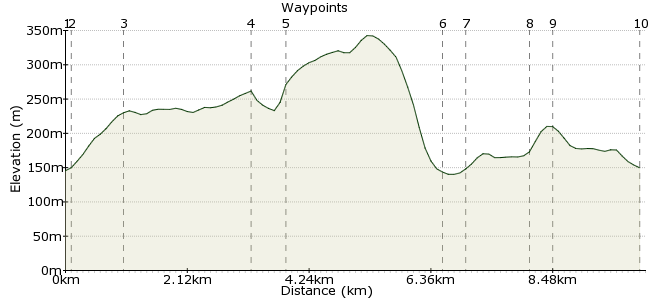
Ascent
198m (649ft)
Descent
194m (636ft)
Max. Elevation
350m (1148ft)
Altitude Gain & Loss
392m (1285ft)
Start & End
Dolwyddelan
Distance
10.10km
(6.28mi)
(6.28mi)
Duration
~3:30h
Difficulty
Moderate
Ordnance Survey Map

Walk Functions
Share
Nearby Walks
Lledr Valley
A leisurely, circular walk (riverside) starting in Clwyd, Wales, about 8.30km (5.16 mi) long, duration: ~2:30h.Moel Siabod - the best views in Snowdonia
A leisurely, circular walk (mountain (above 600m)) starting in Clwyd, Wales, about 8.20km (5.10 mi) long, duration: ~4:15h.Capel Curig
A leisurely, circular walk (countryside) starting in Gwynedd, Wales, about 5.70km (3.54 mi) long, duration: ~1:45h.Walk Map
- $walk->POI array(0)
Waypoints
OS Grid SH737521
Station, can be combined with my oldest walk Lledr Valley with a break for lunch, perhaps, at Y Gwydyr free house! Exit the station to the left, turn left over bridge.
OS Grid SH737520
Keep eyes peeled to right to see sign for Cwm Penamnem on forestry road below 2 houses, follow to waypoint 3.
About 0.12 km (~0.07 miles) from 
OS Grid SH737512
Take path to right footprint on waypost.
About 0.83 km (~0.52 miles) from 
OS Grid SH736490
Take path to right signed for Pont Carreg Alltrem, past small waterfall, across bridge to picnic area.
About 2.16 km (~1.34 miles) from 
OS Grid SH732494
Turn right, pass Tai (house) Penamnem ruins, follow back into Dolwyddelan.
About 0.56 km (~0.35 miles) from 
OS Grid SH736521
Turn left, pass St. Gwyddelan's Church. It was open when I visited, small on the outside but a lovely interior, see pictures at Flickr.
About 2.70 km (~1.68 miles) from 
OS Grid SH734524
Turn left onto right-hand footpath by Castle Terrace, follow to sign for Castle.
About 0.32 km (~0.2 miles) from 
OS Grid SH723523
Easy climb up to Castle, look for Cadw Sign "Tickets from buildings below left".
About 1.09 km (~0.68 miles) from 
OS Grid SH720524
Out of season on day I visited, retrace walk back down into village, Y Gwydyr free house on left of waypoint 7 with bus stop for Express Motors X1 or back to station.
About 0.33 km (~0.21 miles) from 
 End of walk
OS Grid SH735524
Weather wasn't too kind today, misty and drizzly, take into account if you view my photos at Flickr. But a nice walk with local history – enjoy!
About 1.51 km (~0.94 miles) from 

1 comment... join the discussion!
driver 16
Search for first waypoint Dolwyddelan site didn't recognise had to work up from Betws y Coed by following railway.