Church Stretton to Craven Arms
A moderate walk (low hills and fells (below 600m)) starting and finishing in Shropshire, England, about 14.40km (8.95 mi) long with an estimated walking time of about 5:00h. It is unsuitable for families with children, prams & pushchairs, wheelchairs.
Elevation Profile
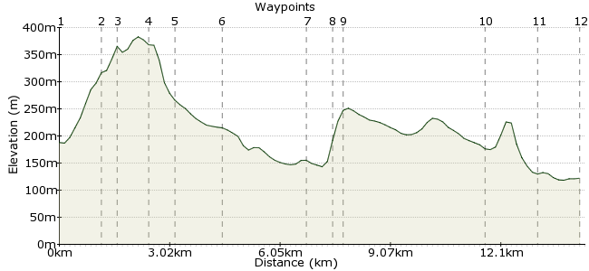
Ascent
272m (892ft)
Descent
338m (1108ft)
Max. Elevation
390m (1279ft)
Altitude Gain & Loss
610m (2000ft)
Start
Church Stretton
End
Craven Arms
Distance
14.40km
(8.95mi)
(8.95mi)
Duration
~5:00h
Difficulty
Moderate
Ordnance Survey Map
This is one of many car-free routes provided by The Shropshire Way. You can download the routes from this link: www.shropshirewalking.co.uk/shropshire-way/linear-walks.php
Church Stretton is designated a ‘walkers are welcome’ town, you will find everything you need to begin your walk here. The walk takes you past Acton Scott historic Working Farm, where you can stop for refreshments. The walk ends at the Shropshire Hills Discovery Centre which includes a café, toilets and visitor information.
Walk Functions
Share
Nearby Walks
Caer Caradoc walk
A moderate, walk (low hills and fells (below 600m)) starting in Shropshire, England, about 11.00km (6.84 mi) long, duration: ~3:30h.Little Caradoc and Caer Caradoc
A leisurely, circular walk (low hills and fells (below 600m)) starting in Shropshire, England, about 7.70km (4.78 mi) long, duration: ~2:45h.Church Stretton - Long Mynd
A moderate, circular walk (low hills and fells (below 600m)) starting in Shropshire, England, about 9.70km (6.03 mi) long, duration: ~3:30h.Walk Map
- $walk->POI array(0)
Waypoints
OS Grid SO455935
The walk starts at the junction of Sandford Avenue & Central Avenue. From platform 1 the train station drive leads to this junction. Or from the bus stop in Beaumont Road turn left into Sandford Avenue and the junction is second on the right. Proceed along Central Avenue and take the surfaced footpath on the left after 250 yards. This passes over a footbridge and then reaches the very busy A49 road. Cross with care. The path runs between gardens to cross a road and continues to climb between more gardens to reach another
road. Go right and then left to climb Ragleth Road. Go right up Poplar Drive and you’ll find a path at the top.
OS Grid SO461925
The path climbs up the hillside. Ignore the stile into Gough’s Coppice but instead follow it left and then right beneath broadleaved trees to cross a stile. It becomes steeper now and go over the stile. At the junction beneath an oak tree keep left and the path bends again but still rising all of the time. You soon reach the open ground where there are rewarding views of Caradoc, the Clee Hills and Wenlock Edge.
About 1.23 km (~0.76 miles) from 
OS Grid SO457925
You will approach a stile by a barred gate but do not go over it. Your way is to the right up the bracken clad hillside on a green swathe to the high ground of Ragleth Hill. At the top there’s a superb view of Hope Bowdler church. The path runs along Ragleth Hill with panoramic views of the area around Church Stretton.
About 0.40 km (~0.25 miles) from 
OS Grid SO452919
On reaching the pole you will find a path down; it is a steep descent and you have to be sure footed for this one. It drops to a
line of trees which you follow down to the hillside to cross a stile and bear slightly left and down to cross another stile. Head
slightly left again to rise up to another stile. Go over this and head in a similar direction to walk alongside a hedge to a stile
leading onto a road.
About 0.80 km (~0.5 miles) from 
OS Grid SO451912
Go right on the road and follow for approximately one mile to the village of Acton Scott. At the junction, go left. Just beyond the entrance road to Acton Scott Historic Working Farm, there’s a stile on the right and the footpath leads through a grassy car park to a stile in the corner. Go over here and head slightly right across the field to cross another stile into a wood. Keep to the left and it soon exits on the left into a pasture.
About 0.65 km (~0.4 miles) from 
OS Grid SO455899
Turn right in the field and at the boundary cross a stile. In the next field, head slightly right to rise to a stile in the hedge.
Once over proceed in a similar direction through a very long field, ignoring the Shropshire Way circular walk going right.
There are waymarker posts at several points but aim slightly right and eventually you will reach the far bottom right corner.
Cross a stile, turn left and cross a second stile. This is the remnant of the old railway line between Craven Arms and Wellington.
About 1.40 km (~0.87 miles) from 
OS Grid SO468881
Emerge into a large field. Your way is slightly right to the far corner where you join a tractor track heading in the direction
of Wolverton farm. As you approach the farm go left up steps and through a gate into the adjacent field on the left. Go slightly right across the field to a gate onto the road.
About 2.14 km (~1.33 miles) from 
OS Grid SO473875
Cross this and go through the wicket gate and keep ahead to the Byne Brook where you’ll find a footbridge. Over the bridge
and head slightly left to an adjacent field. Now turn right to start the climb of Wenlock Edge. On reaching the corner enter
Wolverton wood and after approximately 100 metres take a right turn (onto 2nd track). This stony path climbs right and up the
hillside under a magnificent canopy of broad leaved trees to reach the waymarked bridleway.
About 0.78 km (~0.48 miles) from 
OS Grid SO472873
Join the bridleway which runs along the Wenlock Edge. Turn right and follow this often muddy bridleway for about 1 ½ miles (around 40 minutes). Where it begins to open it soon reaches a junction by an electric telegraph pole. Go left here and walk down the track to a tarmac road. Turn right and right again at the next junction. The lane bends to the right by the entrance to Callow Hill and runs through to the hamlet of Lower Dinchope. Go right here and then keep ahead at the next two junctions.
About 0.22 km (~0.14 miles) from 
OS Grid SO451842
The road rises up to a junction of paths. Go left to cross a stile and head slightly right up the hillside heading to the left of a crown of trees. Walk along the ridge and head right at the waymark to descend the edge. Cross the stile and descend through
Halford wood and then aim slightly left to cross a stile into the next field. Cross a stile beneath an oak tree. Keep ahead by the hedge to cross a stile onto the road. Take care as you cross it to enter a field opposite.
About 3.79 km (~2.35 miles) from 
OS Grid SO443830
Head slightly left to follow the edge of the stream. Cross a stile and continue
ahead moving away from the stream. Go over the bridge over the Onny
River and the path now continues along a lane past the community garden
to the Discovery Centre.
About 1.46 km (~0.91 miles) from 
 Craven Arms
OS Grid SO431828
There are bus stops on the main A49 near to the
Discovery Centre for buses to Ludlow or Shrewsbury. The walk to the railway
station takes about 10 minutes and is signposted through the town.
About 1.15 km (~0.71 miles) from 
