Snaelfell to Laxey 'off piste' in places!
A moderate walk (low hills and fells (below 600m)) starting and finishing in , , about 11.90km (7.39 mi) long with an estimated walking time of about 3:30h. It is unsuitable for families with children, prams & pushchairs, wheelchairs.
Elevation Profile
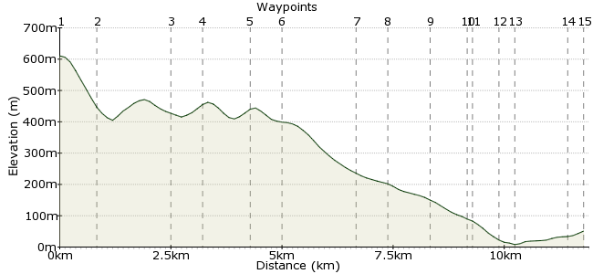
Ascent
92m (301ft)
Descent
652m (2139ft)
Max. Elevation
620m (2034ft)
Altitude Gain & Loss
744m (2440ft)
Start
Snaefell
Distance
11.90km
(7.39mi)
(7.39mi)
Duration
~3:30h
Difficulty
Moderate
Ordnance Survey Map
 2Created by mac.hawk on 17 Feb 2015
From Snaefell to Laxey across the open moor at times - you could use the obvious footpath to the south, but those hills gotta be climbed!! Road walking in the latter part of the route but King Orry's Grave is a must see & Old Laxey is lovely. Mountain railway (or a lot of walking) to the start point - or link it with the Laxey to Snaefell walk for a fabulous full days walk. Approx 8 1/2 miles.
Walk Functions
Share
Nearby Walks
Laxey beach to Snaefell Summit
A moderate, linear walk (countryside) starting in Isle of Man, Isle of Man, about 9.80km (6.09 mi) long, duration: ~4:30h.Glen Mona & Port Cornaa
A leisurely, circular walk (countryside) starting in Isle of Man, England, about 9.30km (5.78 mi) long, duration: ~3:15h.Kirk Michael to St John's
A moderate, linear walk (countryside) starting in , , about 12.00km (7.46 mi) long, duration: ~3:30h.Walk Map
- $walk->POI array(0)
Waypoints
OS Grid SC397880
From Snaefell summit take the path to the trig pillar, pass the buildings ahead and head NE downhill. Cross the rail tracks with care and head for the A18 and Black Hut.
OS Grid SC405884
Directly cross the road and follow the path that rises the hill and take the right hand path (Clagh Ouyr & North Barrule are for another day!).
About 0.87 km (~0.54 miles) from 
OS Grid SC420877
Follow the path for a little over a mile and a little beyond a junction head directly uphill to the summit if Slieau Lhean.
About 1.67 km (~1.04 miles) from 
OS Grid SC426877
From the summit keep to the high ground and follow the open moor across to Slieau Ouyr summit.
About 0.63 km (~0.39 miles) from 
OS Grid SC436879
The route descends fairly gently and a basic/faint path keeps you on the open moor and head SE to Sileau Ruy.
About 1.00 km (~0.62 miles) from 
OS Grid SC441872
The faint (squishy) path continues directly down Slieau Ruy towards The Dreem where it joins a wide track leading to The Clarum.
About 0.80 km (~0.5 miles) from 
OS Grid SC444857
Go through a wide gate and follow Clarum Lane down to the B11 Road.
About 1.52 km (~0.94 miles) from 
OS Grid SC448852
At the road turn right and follow the road for 3/4 of a mile
About 0.65 km (~0.4 miles) from 
OS Grid SC446843
At the sharp righ turn ignore the Raad ny Foillan wayposts and keep on the road for another 1/4 mile.
About 0.92 km (~0.57 miles) from 
OS Grid SC438844
Shortly after the road turns left reach King Orry's Grave (it's on both sides of the road) shortly after which reach the junction of the Douglas/Ramsey road.
About 0.71 km (~0.44 miles) from 
OS Grid SC438843
Cross the road and directly follow Minorca Hill downhill into Old Laxey.
About 0.14 km (~0.09 miles) from 
OS Grid SC441838
Cross the river and turn left to reach the harbour/shore (toilets & cafe here).
About 0.55 km (~0.34 miles) from 
OS Grid SC442836
Retrace your steps the the bridge over the river, cross and turn left up Glen Road for a little over 1/2 mile (following the river upstream).
About 0.23 km (~0.14 miles) from 
OS Grid SC433843
At Laxey Woolen Mills (worth a visit) carry on straight ahead to reach a grassed area and the Lady Evelyn waterwheel.
About 1.12 km (~0.7 miles) from 
 The Lady Evelyn
OS Grid SC432846
Have a close look at the waterwheel then exit by the access boardwalk onto the Douglas/Ramsey road where trams and buses to either are available. The walk is about 8 1/2 miles long.
About 0.31 km (~0.19 miles) from 
