Shibden valley walk
A leisurely walk (countryside) in West Yorkshire, England, about 10.10km (6.28 mi) long with an estimated walking time of about 3:30h. It is suitable for families with children, but unsuitable for prams & pushchairs, wheelchairs.
Elevation Profile
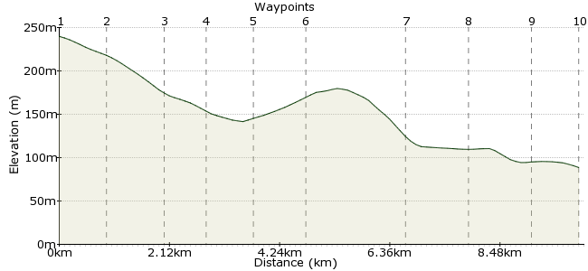
Ascent
253m (830ft)
Descent
260m (853ft)
Max. Elevation
240m (787ft)
Altitude Gain & Loss
513m (1683ft)
Start & End
Stump Cross
Distance
10.10km
(6.28mi)
(6.28mi)
Duration
~3:30h
Difficulty
Leisurely
Ordnance Survey Maps
A 7.5 mile walk around the Shibden Valley, with fantastic views, some hills and varying paths (from bridleways to muddy woodland paths). Easy access by bus from Halifax, or from Bradford (bus 681) or Leeds (508).
Walk Functions
Share
Nearby Walks
Huddersfield to Mirfield
A moderate, linear walk (countryside) starting in Kirklees, England, about 11.20km (6.96 mi) long, duration: ~3:30h.Mirfield Circular
A moderate, walk (countryside) starting in Yorkshire and the Humber, England, about 10.60km (6.59 mi) long, duration: ~3:15h.Hebden Bridge Birthday Walk
A moderate, circular walk (countryside) starting in West Yorkshire, England, about 12.40km (7.71 mi) long, duration: ~4:15h.Walk Map
- $walk->POI array(0)
Waypoints
OS Grid SE107262
Start the walk at Stump Cross, just outside Halifax.
OS Grid SE097262
Take the path heading west towards Claremount.
About 0.92 km (~0.57 miles) from 
OS Grid SE092271
Follow the path above Shibden Dale to the ski slope.
About 1.08 km (~0.67 miles) from 
OS Grid SE086275
The path continues around Pule Hill.
About 0.74 km (~0.46 miles) from 
OS Grid SE091283
Cross the road and descend into the valley via the Calderdale Way.
About 0.88 km (~0.55 miles) from 
OS Grid SE098277
Stay on the path past Dam Head.
About 0.93 km (~0.58 miles) from 
OS Grid SE117278
The Calderdale Way continues all the way to Stone Chair. On the edge of the town, take the path heading south.
About 1.89 km (~1.17 miles) from 
OS Grid SE124270
Follow the road to Coley, just outside Northowram. By the cemetery, the path returns towards the starting point.
About 1.16 km (~0.72 miles) from 
OS Grid SE116261
Continue along the hillside path, passing under the A6036 to reach the starting point.
About 1.16 km (~0.72 miles) from 
 Stump Cross again
OS Grid SE107261
Finish back at Stump Cross for the bus home.
About 0.91 km (~0.57 miles) from 
