Knoydart's headland
A strenuous walk (coast) in Highlands, Scotland, about 20.70km (12.86 mi) long with an estimated walking time of about 6:45h. It is unsuitable for families with children, prams & pushchairs, wheelchairs.
Elevation Profile
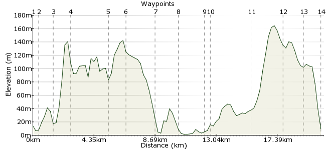
Ascent
254m (833ft)
Descent
259m (849ft)
Max. Elevation
170m (557ft)
Altitude Gain & Loss
513m (1682ft)
Start & End
Inverie
Distance
20.70km
(12.86mi)
(12.86mi)
Duration
~6:45h
Difficulty
Strenuous
Ordnance Survey Maps
If you have a day to spare on Knoydart and aren't tempted by one of the hills, then this coastal walk will be just right. Although much of the route is on roads, these are quiet tracks passing through the moorland to connect some of Knoydart's isolated communities. The coastline is wonderful - check for otters and seals as you go - and the walk is not completely straightforward, with a tricky river crossing halfway round. There are leaflets detailing the walk in the Knoydart Foundation office in Inverie (www.knoydart-foundation.com)
Walk Functions
Share
Nearby Walks
Ladhar Bheinn from Inverie
A strenuous, circular walk (mountain (above 600m)) starting in Highland, Scotland, about 20.50km (12.74 mi) long, duration: ~9:00h.Loch an Nostarie
A leisurely, circular walk (countryside) starting in Highlands, Scotland, about 5.90km (3.67 mi) long, duration: ~1:45h.Carn a' Mhadaidh-ruidh - a route around Lochaber
A moderate, linear walk (low hills and fells (below 600m)) starting in Highland, Scotland, about 12.40km (7.71 mi) long, duration: ~5:00h.Walk Map
- $walk->POI array(0)
Waypoints
OS Grid NG765002
Start at Inverie (boat from Mallaig - no buses or trains out here!)
OS Grid NG760004
From the harbour, follow the road heading west along the coast.
About 0.48 km (~0.3 miles) from 
OS Grid NG751006
At the fork, take the upper road that heads uphill.
About 0.92 km (~0.57 miles) from 
OS Grid NG738007
The road heads across the moorland-covered hills and past Glaschoille Loch.
About 1.36 km (~0.85 miles) from 
OS Grid NG721026
Continue past the turn-off to the remote farm at Sandaig. Actually, forget the adjective - assume everything mentioned is remote unless stated otherwise.
About 2.53 km (~1.57 miles) from 
OS Grid NG711032
As you veer north, look for the sign that says 'Doune here'. The path leads to Doune, where there is, believe it or not, a tea shop. But you need to have rung ahead from Inverie if you wanted a cuppa.
About 1.22 km (~0.76 miles) from 
OS Grid NG716052
This used to be the busiest settlement on Knoydart, and there are still a few people living here. Check the bay as you walk round; seals often swim about here.
About 2.06 km (~1.28 miles) from 
OS Grid NG728060
Continue past the farm at Samadalan, along with the scary-looking but placid cows.
About 1.48 km (~0.92 miles) from 
OS Grid NG743072
At Inverguseran, you need to cross the river. The easiest place is directly opposite the farmhouse on the opposite bank. But only cross if it is safe to do so. If it looks too high or the current is too strong, continue along the same bank you are on. It's a rough path but passable.
About 1.95 km (~1.21 miles) from 
OS Grid NG746073
If you can cross, pass through the farm buildings and join the farm road that follows the valley upstream.
About 0.26 km (~0.16 miles) from 
OS Grid NG760049
It's a beautiful walk alongside the river in one of the most peaceful parts of the UK. Keep your eyes open for birds of prey on the peaks above.
About 2.81 km (~1.75 miles) from 
OS Grid NG766027
Continue along the track, beyond the turning for Ladhar Bheinn.
About 2.28 km (~1.42 miles) from 
OS Grid NG766014
The path drops into a conifer plantation just outside Inverie.
About 1.32 km (~0.82 miles) from 
 The Old Forge
OS Grid NG767000
Head through the holiday cottages, and the path drops you right outside the Old Forge pub. What are the chances? Better go inside for a pint, I guess.
About 1.36 km (~0.85 miles) from 
