Retail therapy?
A leisurely walk (woodland) in Leeds, England, about 7.10km (4.41 mi) long with an estimated walking time of about 2:00h. It is suitable for families with children, but unsuitable for prams & pushchairs, wheelchairs.
Elevation Profile
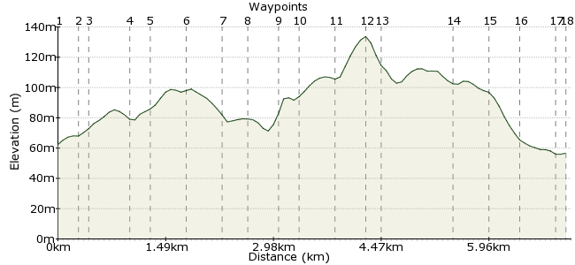
Ascent
89m (291ft)
Descent
95m (311ft)
Max. Elevation
140m (459ft)
Altitude Gain & Loss
184m (602ft)
Start & End
White Rose Centre, Leeds
Distance
7.10km
(4.41mi)
(4.41mi)
Duration
~2:00h
Difficulty
Leisurely
Ordnance Survey Maps
 2Created by mac.hawk on 25 May 2015
Leave the wife/husband/partner/loved one/friend etc to their retail therapy and take a 2 hour-ish wander around urban woodland from the White Rose Centre, Leeds. Load of buses from the surrounding West Yorkshire area call at the centre (too many to list here - visit wymetro.com). Particularly lovely in May/June when the bluebells/hawthorn or buttercups are in flower.
Walk Functions
Share
Nearby Walks
Suburban Leeds stroll
A moderate, linear walk (countryside) starting in Leeds, England, about 15.70km (9.76 mi) long, duration: ~5:00h.Gildersome Loop 1
A leisurely, circular walk (countryside) starting in Leeds, England, about 3.70km (2.30 mi) long, duration: ~1:00h.Dewsbury to Cottingley
A moderate, linear walk (countryside) starting in Kirklees, England, about 14.60km (9.07 mi) long, duration: ~4:30h.Walk Map
- $walk->POI array(0)
Waypoints
OS Grid SE280294
Leave the bus and enter Debenhams store. Go directly through the store and exit into the shopping mall. Carry on directly ahead to reach the central atrium (where the escalators are).
OS Grid SE281292
Take an escalator or the lift to the first floor & exit the mall into the rear car park. Follow the entrance/exit road directly ahead to reach the centre's outer road. Cross & take the pedestrian exit.
About 0.24 km (~0.15 miles) from 
OS Grid SE279291
Take the pedestrian exit to reach the gravel footpath and turn left. Follow the boundary path and where it turns sharp left carry on ahead down a small incline into an open field and turn left.
About 0.19 km (~0.12 miles) from 
OS Grid SE278287
Follow the field boundary (hawthorn hedge at immediate left) as it initially rises the hill then carry on ahead to reach a path with a fence boundary on the right and follow.
About 0.44 km (~0.27 miles) from 
OS Grid SE279285
Follow the fence (on right) ahead to shortly turn sharp right then (again shortly) turn left for approx 200 yards to reach the t-junction at Peter Lane.
About 0.27 km (~0.17 miles) from 
OS Grid SE280280
Turn left & follow Peter Lane as it passes the trig pillar on the left in the hawthorn to descend to the A653 dual carriageway.
About 0.47 km (~0.29 miles) from 
OS Grid SE284281
At the A653 turn right. Cross the dual carriageway with care as/when you can (the verges are wide & walkable) and take a track on the left just before the roundabout.
About 0.45 km (~0.28 miles) from 
OS Grid SE285279
Follow the track under the (in use) railway bridge, then the disused railway bridge & turn right. At the top of the initial rise climb the embankment on the right & follow the old railway line left.
About 0.31 km (~0.19 miles) from 
OS Grid SE289279
The old railway embankment runs a short distance before you descend where an old bridge once was. Do not re-ascend the embankment but follow the path that runs ahead adjacent it.
About 0.38 km (~0.24 miles) from 
OS Grid SE290277
Reach a heavily eroded short uphill section that leads to an open area. Carry on ahead to re-enter woodland along a very wide track. Follow the track that shortly exits the woodland.
About 0.24 km (~0.15 miles) from 
OS Grid SE291273
Turn left along a gravel path and follow as it rises quite steeply uphill a short distance to a T-junction on the brow of the hill. Turn left.
About 0.42 km (~0.26 miles) from 
OS Grid SE293276
Follow the brow of the hill until just before reaching housing and turn left downhill along a path heading slightly right towards woodland.
About 0.33 km (~0.21 miles) from 
OS Grid SE291276
Reach a junction and turn right and follow the wide path into the woodland for about 1/2 mile. Pass an open field area on the left to reach an open field directly ahead.
About 0.14 km (~0.09 miles) from 
OS Grid SE287284
Ahead is a wide open field but the track runs around the left hand edge. Follow and at the end of the open area, where the track veers right take a path on the left towards the railway fencing.
About 0.91 km (~0.57 miles) from 
OS Grid SE286288
Reach the railway fencing on the left & follow to reach a footbridge on the left, cross & follow the track to reach Stank Hall Barn on the right.
About 0.41 km (~0.25 miles) from 
OS Grid SE284291
Pass the barn & follow the exit road down hill. Take care and directly cross the dual carriageway ahead & veer left and follow the road with the houses of (old) Millshaw Road on your right.
About 0.33 km (~0.21 miles) from 
OS Grid SE283295
Carry on ahead to follow the A653 on your left to reach a pelican crossing. Cross the road, turn right and at the roundabout turn left towards the shopping centre.
About 0.42 km (~0.26 miles) from 
 White Rose Centre
OS Grid SE281295
At the roundabout cross ahead and follow the footpath to the bus station. The walks about 4 1/2 miles long.
About 0.17 km (~0.11 miles) from 
