Carningli Common and Cwm Gwaun
A moderate walk (riverside) in national park Pembrokeshire Coast in Pembrokeshire (Sir Benfro), Wales, about 18.40km (11.43 mi) long with an estimated walking time of about 6:45h. It is suitable for families with children, but unsuitable for prams & pushchairs, wheelchairs.
Elevation Profile
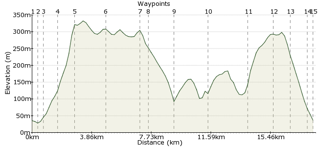
Ascent
499m (1637ft)
Descent
498m (1633ft)
Max. Elevation
340m (1115ft)
Altitude Gain & Loss
997m (3270ft)
Start & End
Newport, Pembrokeshire
Distance
18.40km
(11.43mi)
(11.43mi)
Duration
~6:45h
Difficulty
Moderate
Ordnance Survey Map
A walk of two halves, this one. The first half takes you over three small volcanoes that lie south-west of Newport, with good views on all sides as you progress. The second half follows the secretive Cwm Gwaun, including the pub at Pontfaen, to offer a varied day out.
Walk Functions
Share
Nearby Walks
Moylgrove to St. Dogmaels.
A moderate, walk (coast) starting in Pembrokeshire, Wales, about 11.60km (7.21 mi) long, duration: ~3:45h.Dinas Head on the Pembrokeshire Coast
A moderate, linear walk (coast) starting in Pembrokeshire (Sir Benfro), Wales, about 12.60km (7.83 mi) long, duration: ~4:00h.Newgale to Solva
A leisurely, linear walk (coast) starting in Pembrokeshire (Sir Benfro), Wales, about 6.00km (3.73 mi) long, duration: ~1:45h.Walk Map
- $walk->POI array(0)
Waypoints
OS Grid SN054391
Take the bus to Newport in Pembrokeshire (note there is more than one Newport in Wales).
OS Grid SN059391
Head east along the main road through the town.
About 0.42 km (~0.26 miles) from 
OS Grid SN060389
At Feidr Bentick, head south along the road.
About 0.26 km (~0.16 miles) from 
OS Grid SN066383
At the telephone box, leave the road and climb up to Carningli Common via the footpath.
About 0.87 km (~0.54 miles) from 
OS Grid SN061372
There are several Bronze Age sites on this ancient volcano. Once on the summit, head west along the high ground.
About 1.18 km (~0.73 miles) from 
OS Grid SN044365
Continue to the second summit of Mynydd Caregog.
About 1.88 km (~1.17 miles) from 
OS Grid SN022362
Cross the road and onto the third summit, Mynydd Melyn.
About 2.24 km (~1.39 miles) from 
OS Grid SN020358
Head for the road and cross over, then take the track leading downhill into the river valley.
About 0.44 km (~0.27 miles) from 
OS Grid SN006349
A change of pace for the second half of the walk as you follow the riverside in Cwm Gwaun.
About 1.69 km (~1.05 miles) from 
OS Grid SN026340
Follow the river heading east. There is a wonderful old-fashioned pub at Pontfaen, the Dyffryn Arms, where beer is still served from jugs!
About 2.19 km (~1.36 miles) from 
OS Grid SN049350
At Pen-Lan-Uchaf, you have two options: continue via the river to the start, or take the shorter but steeper route via the saddle to Newport.
About 2.47 km (~1.53 miles) from 
OS Grid SN049366
If opting for the steep option, take the path through the forest and continue via the saddle between Mynydd Carningli and Mynydd Caregog.
About 1.67 km (~1.04 miles) from 
OS Grid SN051377
Skirt around the summit and drop down towards the town.
About 1.13 km (~0.7 miles) from 
OS Grid SN055386
Re-enter Newport at Castle Hill, from where it's a short walk back into town.
About 0.92 km (~0.57 miles) from 
 Bus stop
OS Grid SN056390
Back to the town centre for the bus home.
About 0.46 km (~0.29 miles) from 
