The John Muir Way - Dunbar to North Berwick
A moderate walk (countryside) starting and finishing in East Lothian, Scotland, about 19.30km (11.99 mi) long with an estimated walking time of about 5:45h. It is suitable for families with children, but unsuitable for prams & pushchairs, wheelchairs.
Elevation Profile
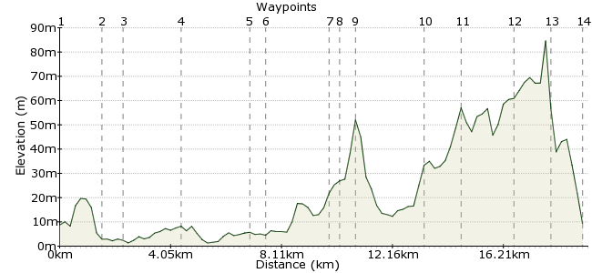
Ascent
86m (282ft)
Descent
85m (278ft)
Max. Elevation
90m (295ft)
Altitude Gain & Loss
171m (560ft)
Start
Dunbar
End
North Berwick
Distance
19.30km
(11.99mi)
(11.99mi)
Duration
~5:45h
Difficulty
Moderate
Ordnance Survey Map
This day walk follows one of the best sections of the John Muir Way, a 45-mile walk created to commemorate the great conservationist. It's flat by Scottish standards, but the mix of coastal scenery and countryside is well worth heading here for. There are buses between the two towns, and both have regular trains to Edinburgh.
Walk Functions
Share
Nearby Walks
Dunbar coastal
A leisurely, circular walk (coast) starting in East Lothian, Scotland, about 6.10km (3.79 mi) long, duration: ~1:30h.North Berwick Law
A leisurely, circular walk (low hills and fells (below 600m)) starting in East Lothian, Scotland, about 2.50km (1.55 mi) long, duration: ~1:00h.Wallyford to Musselburgh
A leisurely, linear walk (countryside) starting in East Lothian, Scotland, about 7.80km (4.85 mi) long, duration: ~2:30h.Walk Map
- $walk->POI array(0)
Waypoints
OS Grid NT679792
Start in Dunbar. From the harbour, follow the seafront and look for signs for the John Muir Way.
OS Grid NT662792
Too early for a pint of Belhaven Best, but there'll be one waiting at the end. Continue along the JMW around the coast.
About 1.67 km (~1.04 miles) from 
OS Grid NT661785
Continue along the coast towards West Barns.
About 0.65 km (~0.4 miles) from 
OS Grid NT641788
Keep going through Hedderwick Hill in the John Muir Country Park.
About 2.02 km (~1.26 miles) from 
OS Grid NT617781
The path leaves the coast and heads inland. Near Kirklandhill, take the path alongside the A198.
About 2.46 km (~1.53 miles) from 
OS Grid NT613784
Head under the bridge and take the riverside path.
About 0.52 km (~0.32 miles) from 
OS Grid NT592777
Follow the River Tyne into East Linton.
About 2.21 km (~1.37 miles) from 
OS Grid NT588776
The path leads you along the high street and out of the village via the northern side.
About 0.38 km (~0.24 miles) from 
OS Grid NT583780
Continue over Drylawhill, from where the JMW heads northwards through the fields.
About 0.67 km (~0.42 miles) from 
OS Grid NT577804
Keep on the signposted route through Stonelaws.
About 2.44 km (~1.52 miles) from 
OS Grid NT571814
The path leaves the road at Craigmoor Wood.
About 1.14 km (~0.71 miles) from 
OS Grid NT563831
As you leave the woods, North Berwick Law looms ahead. It's not part of the route, so no need to climb it...
About 1.92 km (~1.19 miles) from 
OS Grid NT553841
...oh go on then, it's only little. And steep. And bigger than it looks. Make the top and you've earned an extra pint at the end. And some cheesy nibbles.
About 1.39 km (~0.86 miles) from 
 Berwick Bay
OS Grid NT552853
Continue into North Berwick and aim for the coast. The JMW continues westwards, should your legs be calling for another day's walking...
About 1.20 km (~0.75 miles) from 
