The Hope Valley Skyline Walk southern half
A moderate walk (low hills and fells (below 600m)) in national park Peak District starting and finishing in Derbyshire, England, about 16.70km (10.38 mi) long with an estimated walking time of about 6:15h. It is suitable for families with children, but unsuitable for prams & pushchairs, wheelchairs.
Elevation Profile
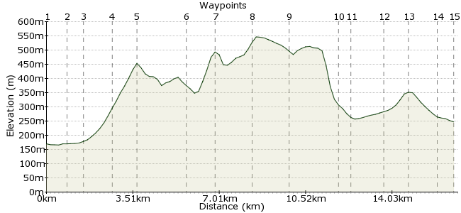
Ascent
544m (1784ft)
Descent
467m (1532ft)
Max. Elevation
550m (1804ft)
Altitude Gain & Loss
1011m (3316ft)
Start
Hope railway station
End
Edale
Distance
16.70km
(10.38mi)
(10.38mi)
Duration
~6:15h
Difficulty
Moderate
Ordnance Survey Map
 2Created by mac.hawk on 19 Jun 2015
The southern section of the iconic Hope Valley skyline walk. Takes a bit of effort to get to Close Hill summit but once there it's pretty gentle meandering along the ridge-top path that is flagged for much of the way to Mam Tor. The Chapel Gate track is VERY stoney underfoot. Not suitable for very young children (due to length really). VERY popular walk between Lose Hill & Mam Tor.
Walk Functions
Share
Nearby Walks
Across the Divide - Hope to Edale
A leisurely, linear walk (low hills and fells (below 600m)) starting in Derbyshire, England, about 8.60km (5.34 mi) long, duration: ~3:15h.Ladybower, Win Hill & Hope
A leisurely, linear walk (low hills and fells (below 600m)) starting in Derbyshire, England, about 9.00km (5.59 mi) long, duration: ~3:15h.Ladybower from Bamford via High Neb
A moderate, circular walk (low hills and fells (below 600m)) starting in Derbyshire, England, about 18.70km (11.62 mi) long, duration: ~6:30h.Walk Map
- $walk->POI array(0)
Waypoints
OS Grid SK180832
Exit the railway station and take the access road down to the A6187 (Station Road) and turn right towards Hope Village. When possible cross to the right hand side of the road.
OS Grid SK170835
Pass St Peter's Church on your left and immediately after the Woodroffe Arms turn right up a waymarked ginnel. The path between housing becomes signposted to Lose Hill, simply carry on ahead.
About 0.95 km (~0.59 miles) from 
OS Grid SK167840
The footpath continues ahead and leaves the housing behind to enter fenced/hedged sections and crosses the railway.
About 0.56 km (~0.35 miles) from 
OS Grid SK158846
Press on ahead along the route still waymarked to Lose Hill/Mam Tor Ridge as it starts to rises gently through field to reach Lose Hill Farm.
About 1.18 km (~0.73 miles) from 
OS Grid SK152853
The path skirts the farm on your left and rises more steeply until it reaches the summit of Lose Hill. Fantastic views in all directions when the weathers good.
About 0.88 km (~0.55 miles) from 
OS Grid SK134844
Follow the ridge-top walk as it heads over towards Mam Tor, there's a short steepish descent at Black Tor before gently rising to Hollins Cross.
About 1.95 km (~1.21 miles) from 
OS Grid SK126835
Continue along the wide ridge-top path to ascend to the trig pillar at Mam Tor beyond which descend to the road, cross and take the wide path uphill to rejoin the ridge-top walk.
About 1.23 km (~0.76 miles) from 
OS Grid SK111834
Take the ridge-top footpath to pass Lord's Seat (the tumulus of which is currently fenced off) and continue on ahead along Rushup Edge..
About 1.50 km (~0.93 miles) from 
OS Grid SK098829
You leave the ridge-top edge behind and join the bridleway to reach a T-junction. Turn right down Chapel Gate (track).
About 1.44 km (~0.89 miles) from 
OS Grid SK112842
Simply follow Chapel Gate track through a couple of gates to eventually reach a tarmac road. Turn left to reach Barber Booth.
About 1.93 km (~1.2 miles) from 
OS Grid SK112846
At the first junction turn left (there's a lovely Methodist chapel in the hamlet that's worth a look at first) and follow the road to Upper Booth.
About 0.41 km (~0.25 miles) from 
OS Grid SK102852
Turn right through Orchard Farm farmyard and follow the waymarked path (the Pennine Way) towards Edale.
About 1.22 km (~0.76 miles) from 
OS Grid SK111855
The path gently rises to pass below Broadlee Bank Tor before gently descending through fields into Grindsbrook Booth/Edale village.
About 0.96 km (~0.6 miles) from 
OS Grid SK122859
Upon reaching the road turn right and follow for half a mile to reach the railway station on the right. The village has cafes, pubs and an excellent visitor centre (with toilets).
About 1.16 km (~0.72 miles) from 
 Edale railway station
OS Grid SK121853
There are also public toilets by the car park.
The walk is approx 12 and a half miles long.
About 0.64 km (~0.4 miles) from 
