Port Erin Amble
A leisurely walk (coast) in Isle of Man, England, about 5.50km (3.42 mi) long with an estimated walking time of about 2:00h. It is suitable for families with children, but unsuitable for prams & pushchairs, wheelchairs.
Elevation Profile
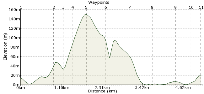
Ascent
173m (567ft)
Descent
168m (551ft)
Max. Elevation
150m (492ft)
Altitude Gain & Loss
341m (1118ft)
Start & End
Port Erin Rail/Bus Station
Distance
5.50km
(3.42mi)
(3.42mi)
Duration
~2:00h
Difficulty
Leisurely
Ordnance Survey Map
 2Created by mac.hawk on 13 Sep 2015
A short walk around Bradda Head to visit a local landmark followed by an amble across the beach or shore road. Buses every 20 mins from Douglas and steam trains during spring/summer/autumn. Extension to the walk takes in the beach and a visit to the harbour & Lifeboat Station.
Toilets at the bus/train station, Bradda Head cafe, Cosy Nook cafe, Strand Road & the harbour.
Walk Functions
Share
Nearby Walks
Castletown, Silverdale Glen and coastal path
A moderate, circular walk (riverside) starting in Isle of Man, Isle of Man, about 11.40km (7.08 mi) long, duration: ~3:15h.Castletown & the Langness Peninsular
A moderate, circular walk (coast) starting in Isle of Man, Isle of Man, about 10.60km (6.59 mi) long, duration: ~3:00h.Port Soderick to Douglas along Marine Drive
A leisurely, linear walk (coast) starting in Isle of Man, Isle of Man, about 7.10km (4.41 mi) long, duration: ~2:00h.Walk Map
- $walk->POI array(0)
Waypoints
OS Grid SC196689
From the bus or rail station head towards the clifftop road and turn right along the Promenade. Pass the golf course on your right and the foot entrance to Bradda Glen on your left. Continue ahead.
OS Grid SC193698
Immediately after passing a large residential parking area on the left turn left down the (signposted) road entrance to Bradda Glenn.
About 0.94 km (~0.58 miles) from 
OS Grid SC191697
Where the road turns sharp left go up the concrete steps directly ahead and follow the path ahead for 50 yards onto the moor and take the first footpath on the right uphill.
About 0.21 km (~0.13 miles) from 
OS Grid SC190698
Soon reach a wide track (with housing at right) and a few paces to the left leads to a path continuing to directly rise the hill to eventually reach the cairn on Bradda Mooar summit.
About 0.23 km (~0.14 miles) from 
OS Grid SC189702
From the cairn take a path that heads right to circle the summit plateau & eventually leads downhill heading in the direction of Milners Tower on Bradda Head. There are commanding views.
About 0.40 km (~0.25 miles) from 
OS Grid SC184699
Several tracks lead to the tower which you can usually ascend if you so wish (a torch is handy). Once again there are commanding views of the SW of the island.
About 0.60 km (~0.37 miles) from 
OS Grid SC190697
There are several routes from the tower back to Bradda Glen, don't take the lowest to the the coast with children as it is un-fenced (follow the wall). Return to point 3.
About 0.65 km (~0.4 miles) from 
OS Grid SC195692
From Bradda Glen either return the way you came or follow the clifftop path through the Glen. Reach the Promenade and descend to the beach near the lighthouse and Cosy Nook cafe.
About 0.68 km (~0.42 miles) from 
OS Grid SC189690
Follow the beach or Shore Road across the bay to the harbour and beyond that the RNLI Lifeboat station.
About 0.61 km (~0.38 miles) from 
OS Grid SC194689
Return along the beach/road and turn right up Strand Road to reach the railway station or continue ahead and turn left along Orchard Road to the bus terminus.
About 0.50 km (~0.31 miles) from 
 Bus terminus
OS Grid SC197690
Walk is approx 7 miles (5 if you skip the visit to the lifeboat station).
St Catherines Church, the Railway Museum & Port Erin Arts Centre are all worth a visit.
About 0.30 km (~0.19 miles) from 
