Garsdale Circular via East Baugh Fell & Rise Hill
A strenuous walk (mountain (above 600m)) in national park Yorkshire Dales in Cumbria, England, about 22.90km (14.23 mi) long with an estimated walking time of about 9:00h (1 overnight stay). It is unsuitable for families with children, prams & pushchairs, wheelchairs.
Elevation Profile
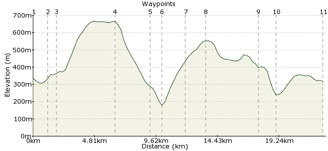
Ascent
775m (2542ft)
Descent
793m (2601ft)
Max. Elevation
670m (2198ft)
Altitude Gain & Loss
1568m (5143ft)
Start & End
Garsdale Railway Station
Distance
22.90km
(14.23mi)
(14.23mi)
Duration
~9:00h
Difficulty
Strenuous
 2Created by mac.hawk on 16 Dec 2015
A long (18 miles), tough walk with 2 steep ascents/descents along open, unwaymarked, non-RoW moorland (it is Access Land though). Not for during or after the rainy season due to extensive areas of bog. Make it after a very dry period or a VERY cold day when the bog will be dry or frozen. Stunning views from the summits. Access via the Leeds-Settle-Carlisle rail line. Limited No 855 bus service.
Walk Functions
Share
Nearby Walks
Garsdale to Kirkby Stephen via High Seat
A strenuous, linear walk (mountain (above 600m)) starting in Cumbria, England, about 21.90km (13.61 mi) long, duration: ~7:45h.Garsdale Rly Station to Kirkby Stephen Rly Station
A moderate, linear walk (low hills and fells (below 600m)) starting in Cumbria, England, about 18.40km (11.43 mi) long, duration: ~6:00h.Garsdale circular to Great Shunner Fell summit
A strenuous, circular walk (mountain (above 600m)) starting in Cumbria, England, about 22.30km (13.86 mi) long, duration: ~8:45h.Walk Map
- $walk->POI array(0)
Waypoints
OS Grid SD787918
Exit the railway station and take the road downhill to the A684 road and turn left. After 200 yards turn right into Old Road. After 1/2 mile turn right into Grisedale Road.
OS Grid SD776913
Follow Grisedale Road for 1/2 mile then turn left onto the open moor, where the OS 1:25000 maps shows 'Riggs'.
About 1.18 km (~0.73 miles) from 
OS Grid SD775921
Simply follow the wall up the moor to the trig pillar at Knoutberry Haw. Keep to the north side of the wall where possible but you may need to 'jump' the wall in places to avoid bog.
About 0.71 km (~0.44 miles) from 
OS Grid SD730919
From the trig pillar simply follow the wall down Ringing Keld Gutter.
About 4.48 km (~2.78 miles) from 
OS Grid SD703919
Before reaching Faw Moor the fence veers left and heads to Garsdale Foot. Follow it to reach a track that passes a farm and reaches a minor road.
About 2.73 km (~1.7 miles) from 
OS Grid SD699913
At the minor road turn right for 1/2 mile to reach the A684 road. At the A684 turn left for 1/4 mile then head right up the open moors of Brockought & Tarn Hill's following the wall on the left.
About 0.74 km (~0.46 miles) from 
OS Grid SD706895
As you near the summit plateau it looks like there are a series of walls to traverse, don't panic, these are either stiled or in a state of disrepair all the way to Will's/Peggy's Hill.
About 1.90 km (~1.18 miles) from 
OS Grid SD720886
Just keep following the wall to the trig pillar and continue along Rise Hill to descend Snaizwold Fell to the bridleway at Will's/Peggy's Hill (walls stiled or in disrepair).
About 1.66 km (~1.03 miles) from 
OS Grid SD760885
Turn left and follow the bridleway to rejoin the A684 road.
About 4.07 km (~2.53 miles) from 
OS Grid SD753897
At the road turn right for 1 1/4 mile then take the minor road (Old Road) on the left and follow it to where you initially joined it shortly after leaving the rail station.
About 1.39 km (~0.86 miles) from 
 Railway Station return
OS Grid SD783918
Retrace the route uphill to the railway station. Route is approx 18 miles as even in the driest or coldest periods you will have to detour in places to avoid bog.
About 3.61 km (~2.24 miles) from 
