Garsdale to Kirkby Stephen via High Seat
A strenuous walk (mountain (above 600m)) in national park Yorkshire Dales starting and finishing in Cumbria, England, about 21.90km (13.61 mi) long with an estimated walking time of about 7:45h. It is unsuitable for families with children, prams & pushchairs, wheelchairs.
Elevation Profile
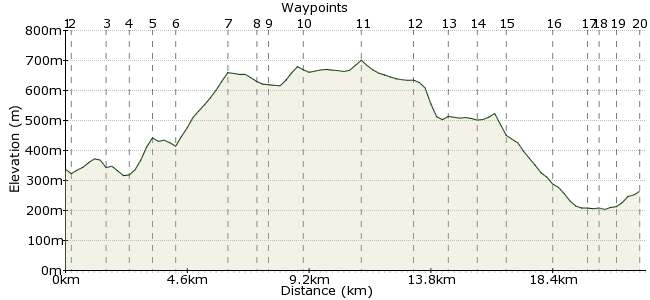
Ascent
531m (1742ft)
Descent
604m (1981ft)
Max. Elevation
710m (2329ft)
Altitude Gain & Loss
1135m (3723ft)
Start
Garsdale Railway Station
End
Kirkby Stephen
Distance
21.90km
(13.61mi)
(13.61mi)
Duration
~7:45h
Difficulty
Strenuous
Ordnance Survey Map
 2Created by mac.hawk on 09 Jan 2016
Yet another walk from the Leeds-Settle-Carlisle railway line. From Calf Moss (6) to the B6270 (13) this one takes you up onto the open moor and whilst the footpaths are there (most of the way) these are not RoW's so there's no waymarking. Bleak and barren for this 7 mile section (but all the more wonderful for that) so if you have an issue with the above avoid this walk. Approx 16 1/2 miles.
Walk Functions
Share
Nearby Walks
Garsdale Circular via East Baugh Fell & Rise Hill
A strenuous, circular walk (mountain (above 600m)) starting in Cumbria, England, about 22.90km (14.23 mi) long, duration: ~9:00h.Garsdale Rly Station to Kirkby Stephen Rly Station
A moderate, linear walk (low hills and fells (below 600m)) starting in Cumbria, England, about 18.40km (11.43 mi) long, duration: ~6:00h.Wild Boar Fell
A moderate, linear walk (mountain (above 600m)) starting in Cumbria, England, about 17.90km (11.12 mi) long, duration: ~6:30h.Walk Map
- $walk->POI array(0)
Waypoints
OS Grid SD787918
Exit the railway station and follow the road downhill to the T-Junction and turn right for 200 yards to reach a wayposted footpath on the left.
OS Grid SD788921
Take the RoW across Garsdale Low Moor to reach a footbridge over the railway line, and cross.
About 0.37 km (~0.23 miles) from 
OS Grid SD790934
Once over the footbridge take the RoW ahead or right to reach the road, cross and take either footpath to cross the infant River Ure to reach the farm at Blades.
About 1.29 km (~0.8 miles) from 
OS Grid SD796937
From the farm take the obvious path that rises the hill ahead through fields to reach a wide track (The High Way) at High Dyke.
About 0.73 km (~0.45 miles) from 
OS Grid SD802943
At High Dyke turn left along the wide track for 2/3 mile to the northern end of the walled enclosure of Calf Moss.
About 0.77 km (~0.48 miles) from 
OS Grid SD796950
Leave the wide track at the north western end of the enclosure and enter the open moor, initially following the line of the wall on your right.
About 0.93 km (~0.58 miles) from 
OS Grid SD807965
Leave the wall behind and continue to rise the hill, now veering NE (diagonally half left) to reach Lunds Fell summit plateau at Sails.
About 1.89 km (~1.17 miles) from 
OS Grid SD806975
From Sails turn due N along the summit plateau towards Little Fell, cross a wall/fence after 2/3 mile then shortly reach a second wall/fence at Scarth of Scaiths.
About 1.02 km (~0.63 miles) from 
OS Grid SD806979
Upon reaching the fence follow it right briefly (if needed) to where it turns north following the county boudary keeping the fence on your left.
About 0.39 km (~0.24 miles) from 
OS Grid SD810991
Cross another fence and continue with fence on your left to reach Hugh Seat (a very minor detour to Ladies Pillar is worth the effort)
About 1.21 km (~0.75 miles) from 
OS Grid NY802012
Shortly after Hugh Seat cross another fence and continue along the summit plateau path to pass Gregory Chapel and reach High Seat after 1 1/2 miles.
About 2.27 km (~1.41 miles) from 
OS Grid NY802031
From High Seat continue in the same direction as the route starts to descend fairly gently to High Pike Hill.
About 1.94 km (~1.21 miles) from 
OS Grid NY810040
The route descends more steeply to reach the B6270 road. Turn left briefly then continue north along the wayposted bridleway for 2/3 mile to reach a broken wall.
About 1.19 km (~0.74 miles) from 
OS Grid NY811051
At the broken wall leave the bridleway and follow the wall (with it on your right) to circumnavigate Tailbridge Hill.
About 1.09 km (~0.68 miles) from 
OS Grid NY802056
As you circle Tailbridge Hill just follow the wall on your right as you descend to rejoin the B6270 road approx 1 mile east of Nateby.
About 1.03 km (~0.64 miles) from 
OS Grid NY785063
Upon rejoining the B6720 road carry on down hill into Nateby.
About 1.87 km (~1.16 miles) from 
OS Grid NY773068
At Nateby take any of the 3 RoW's that lead to the footbridge over the River Eden a little north of Wharton Hall.
About 1.20 km (~0.75 miles) from 
OS Grid NY770064
Cross the footbridge and head directly uphill to a stile, cross onto a track and turn right for half a mile to reach Halfpenny House.
About 0.49 km (~0.3 miles) from 
OS Grid NY768070
At Halfpenny House turn left to follow the (wayposted) tarmac footpath for a little over 1/2 mile to Kirkby Stephen railway station.
About 0.66 km (~0.41 miles) from 
 Kirkby Stephen Railway Station
OS Grid NY761066
Return trains north towards Carlisle & south towards Leeds. Walk is approx 16 1/2 miles long.
About 0.83 km (~0.52 miles) from 
