Shivering Mountain
A moderate walk (low hills and fells (below 600m)) in national park Peak District in Derbyshire, England, about 9.30km (5.78 mi) long with an estimated walking time of about 3:30h. It is suitable for families with children, but unsuitable for prams & pushchairs, wheelchairs.
Elevation Profile
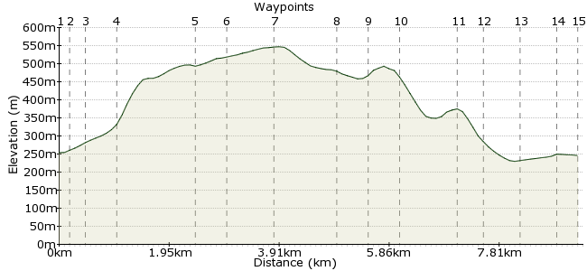
Ascent
313m (1026ft)
Descent
321m (1053ft)
Max. Elevation
550m (1804ft)
Altitude Gain & Loss
634m (2079ft)
Start & End
Barber Booth
Distance
9.30km
(5.78mi)
(5.78mi)
Duration
~3:30h
Difficulty
Moderate
Ordnance Survey Map
 3Created by John Walker on 04 Jun 2016
This circular walk takes in part of a long ridge path on the southern side of the Vale of Edale, including Mam Tor, also known as ‘the Shivering Mountain’ for its tendency to disintegrate slowly in a series of landslips. The route starts with a climb up the closed end of the Vale, to Rushup Edge at the beginning of the ridge and we leave it at Hollins Cross to return to Barber Booth.
Walk Functions
Share
Nearby Walks
Up the Clough
A leisurely, circular walk (low hills and fells (below 600m)) starting in Derbyshire, England, about 7.60km (4.72 mi) long, duration: ~3:00h.Packhorses, Peat and Peewits
A moderate, circular walk (low hills and fells (below 600m)) starting in Derbyshire, England, about 11.40km (7.08 mi) long, duration: ~4:15h.Edale to Hope via Kinder and Alport Castles
A moderate, linear walk (low hills and fells (below 600m)) starting in Derbyshire, England, about 19.70km (12.24 mi) long, duration: ~7:45h.Walk Map
- $walk->POI array(0)
Waypoints
OS Grid SK113847
Barber Booth is a cluster of houses and a chapel, easily reached by train from Manchester or Sheffield via Edale station, just a 15 minute walk away, along the beautiful and peaceful Vale of Edale.
OS Grid SK113846
1. Leave Barber Booth village heading due S to cross a bridge over the River Noe, an attractive small river, rising on the Kinder Scout plateau. In May swathes of bluebells and garlic line the banks.
About 0.16 km (~0.1 miles) from 
OS Grid SK112843
2. Head straight up the minor road & where it veers left go right through a gateway onto a stony path heading diagonally uphill. Newly returned lapwing wheeling, fluttering & calling above our heads.
About 0.25 km (~0.16 miles) from 
OS Grid SK108840
4. As the path becomes steeper you pass through a gate to enter National Trust land. The track becomes steeper as it heads uphill but although stony the going is easy. Bear left up to Rushup Edge.
About 0.53 km (~0.33 miles) from 
OS Grid SK098831
5. Our track is joined by another, coming in from the right, from Dalehead, the NT Bunkhouse, in the secluded valley below. The walk up the hill was punctuated by plaintiff cries of curlews.
About 1.31 km (~0.81 miles) from 
OS Grid SK102830
6. The path follows a beautiful dry stone wall with another parallel one just beyond it, a sheep-pen structure made from the local stone which fractures into flat plates like slate but much thicker.
About 0.44 km (~0.27 miles) from 
OS Grid SK110834
7. The path rises, passing some destroyed or excavated tumuli before reaching a much larger mound enclosed by a fence. This is Lord's Seat. Continue past it as the path follows the narrowing ridge.
About 0.88 km (~0.55 miles) from 
OS Grid SK121834
8. Head down towards a road crossing the ridge through a narrow slot, Mam Nick. Beyond, Mam Tor rises conically with clear signs of banks and ditches from when it was a Bronze & Iron Ages hillfort.
About 1.05 km (~0.65 miles) from 
OS Grid SK125834
9. From the narrow ridge scramble down a steep and rocky path to the road, going left to a gate onto the road. Turn right and walk 100m to the entrance, to climb up a steep slab-paved path to Mam Tor.
About 0.44 km (~0.27 miles) from 
OS Grid SK128838
10. After the trig point continue down the paved track, passing through an impressive bank and ditch and noting the land-slipped surface, especially off to the right. Continue towards a saddle point.
About 0.52 km (~0.32 miles) from 
OS Grid SK135845
This is Hollin's Cross. There is a small memorial stone here. Turn sharp left and head down a steep footpath for walkers only. The path stays close to a dried up stream course with a bank to the right
About 0.92 km (~0.57 miles) from 
OS Grid SK131847
12. Go through a gate by a row of deserted farm cottages to the right. Continue down past a stone barn on the left to reach a bridge over the River Noe. Cross and continue beside the stream to a road.
About 0.45 km (~0.28 miles) from 
OS Grid SK128852
13. Here you can cross over to follow a path across a field then under the railway line to reach the heart of Edale village. For the station, Penny Pot cafe, public toilets and Ramblers Inn, go left.
About 0.57 km (~0.35 miles) from 
OS Grid SK123856
14. Further up this road, past the Ramblers pub is the Moorland Centre with information of all kinds, maps, guide books etc and hot drinks.
About 0.65 km (~0.4 miles) from 
 Edale Station
OS Grid SK122853
15. To return to the start turn into the station yard, go through the car park following a sign 'Barber Booth via field path'. This crosses the track and fields to recross the rails to Barber Booth.
About 0.34 km (~0.21 miles) from 
