Mirfield Circular over Dalton Bank
A leisurely walk (countryside) in West Yorkshire, England, about 9.60km (5.97 mi) long with an estimated walking time of about 3:00h. It is suitable for families with children, but unsuitable for prams & pushchairs, wheelchairs.
Elevation Profile
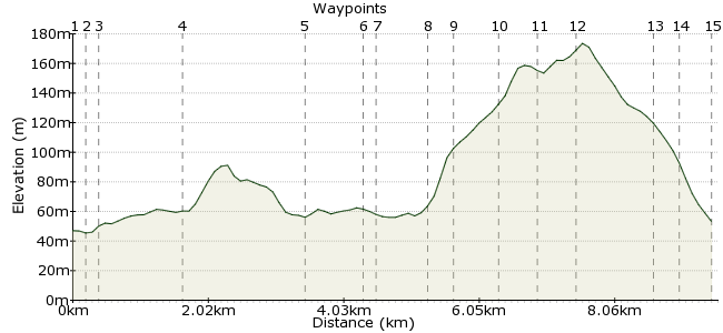
Ascent
126m (413ft)
Descent
119m (390ft)
Max. Elevation
180m (590ft)
Altitude Gain & Loss
245m (803ft)
Start & End
Mirfield
Distance
9.60km
(5.97mi)
(5.97mi)
Duration
~3:00h
Difficulty
Leisurely
Ordnance Survey Map
 2Created by mac.hawk on 09 Jun 2016
Another circular walk from the Leeds-Huddersfield railway line. The initial route follows an old railway line (now a Greenway), briefly joins the canal then rises Dalton Bank to give great views over the surrounding area. Loads of local buses pass through Mirfield (see www.wymetro.com) and the rail service is half hourly Mon-Sat (2 hourly on Sundays).
The walk is approx 7.25 miles long.
Walk Functions
Share
Nearby Walks
Mirfield to Dewsbury along old railway lines
A moderate, linear walk (city/town) starting in West Yorkshire, England, about 10.10km (6.28 mi) long, duration: ~3:00h.Mirfield Circular
A moderate, walk (countryside) starting in Yorkshire and the Humber, England, about 10.60km (6.59 mi) long, duration: ~3:15h.Ravensthorpe Rly Sta to Dewsbury Rly Sta
A moderate, circular walk (countryside) starting in West Yorkshire, England, about 16.30km (10.13 mi) long, duration: ~5:15h.Walk Map
- $walk->POI array(0)
Waypoints
OS Grid SE202195
Exit the railway station head north towards the canal. At the first lane on the left turn left to pass the Navigation Inn.
OS Grid SE201196
Follow the path into a narrow ginnel to shortly reach the main road and turn left under the railway bridge. Veer initially right and follow the road, now veering left to reach the school.
About 0.18 km (~0.11 miles) from 
OS Grid SE199195
From here the route is waymarked as the Calder Valley Greenway for the next couple of miles. Turn right to pass the school on your left and continue ahead following the railway line on the right.
About 0.19 km (~0.12 miles) from 
OS Grid SE188202
Reach a tarmac road (Helm Lane) and continue ahead for 1/3 mile. Where the road turns left enter the woodland ahead and continue along the tarmaced 'Green Lane.
About 1.26 km (~0.78 miles) from 
OS Grid SE171198
The route eventually comes into open ground, passes under a road to reach a long wide viaduct. Cross and beyond which turn right and continue right to descend to the canal.
About 1.78 km (~1.11 miles) from 
OS Grid SE168190
The path leads to a footbridge over the canal by a lock. Cross and turn right along the towpath to pass a second lock and reach a fragile footbridge. Immediately beyond this footbridge turn left.
About 0.81 km (~0.5 miles) from 
OS Grid SE167189
A few paces leads to a road, turn right & 200 yards up the road follow a wayposted footpath on the left between river at left & high wall at right. Soon cross a footbridge over the river & continue.
About 0.18 km (~0.11 miles) from 
OS Grid SE170183
The route leads to a second footbridge & thence the road at the base of Nab Hill/Dalton Bank. Cross the road & turn left briefly to reach a waypost.
About 0.62 km (~0.39 miles) from 
OS Grid SE172181
At the waypost turn right and follow the path as it gently rises to the Nab Hill summit. From the summit turn right and follow the path to the old quarry at Dalton Bank.
About 0.31 km (~0.19 miles) from 
OS Grid SE173187
From the foot of the quarry take either left or right path to climb the to the summit then follow a narrow path ahead that briefly runs along the summit crest.
About 0.66 km (~0.41 miles) from 
OS Grid SE176191
The path enters a field on the right, continues a few paces into the next field then turns right to follow the wall at right to Upper Heaton and reach Bog Green Lane.
About 0.51 km (~0.32 miles) from 
OS Grid SE180188
Turn right to reach a road junction & take the left hand road rising uphill. At the hill plateau take a tarmac track on the left (North Moor Lane) adjacent a wide black gate for 3/4 mile.
About 0.45 km (~0.28 miles) from 
OS Grid SE190192
Upon reaching the tarma road that is Wood Lane turn left. When you reach housing on the right a waymarker post indicates a right turn into the 2nd driveway.
About 1.13 km (~0.7 miles) from 
OS Grid SE192196
Keep to the right of the housing and the footpath leads to a large field. Take a path that leads ahead diagonally left and reach a stile that leads to the footpath we traversed in (3).
About 0.40 km (~0.25 miles) from 
 Hopton Primary School
OS Grid SE196197
Turn right and follow the tarmac track back to Hopton Primary School and follow the route back to the railway station. The walk is approx 7 1/4 miles long.
About 0.42 km (~0.26 miles) from 
