This walk is being edited and not finished! Please do not use it as a guide.
Round walk from Stone in Oxney
A moderate walk (countryside) in Kent, England, about 10.85km (6.74 mi) long with an estimated walking time of about 3:15h. It is unsuitable for families with children, prams & pushchairs, wheelchairs.
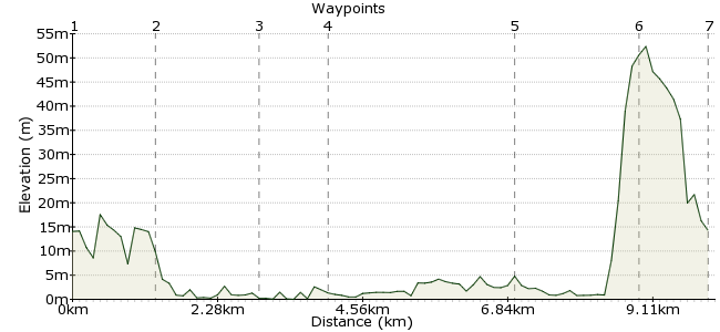
Elevation Profile
Ascent
50m (164ft)
Descent
50m (164ft)
Max. Elevation
60m (196ft)
Altitude Gain & Loss
100m (328ft)
Start & End
Stone in Oxney
Distance
10.85km
(6.74mi)
(6.74mi)
Duration
~3:15h
Difficulty
Moderate
Ordnance Survey Map
A walk which takes in the Royal Military Canal, the Kent marshes, and a beautiful and historic Romney marsh medieval church before crossing over numerous ditches and "sewers" (ditches in Kentish) to run beside the RMC, finishing with a climb up to the Isle of Oxney and a pint at the pub in the village!
Walk Functions
Share
Nearby Walks
Rambling across Romney Marsh
A strenuous, linear walk (countryside) starting in Kent, England, about 22.40km (13.92 mi) long, duration: ~6:30h.Hastings walk
A leisurely, circular walk (coast) starting in East Sussex, England, about 7.50km (4.66 mi) long, duration: ~2:30h.Harrison's Rocks from Eridge
A moderate, circular walk (countryside) starting in Kent, England, about 15.10km (9.38 mi) long, duration: ~4:30h.Walk Map
- $walk->POI array(0)
Waypoints
OS Grid TQ939278
Park at pub in centre of vilage and then walk down to the first left hand turning until you come to the church. Take the footpath down to Mackley farm and then turn left on to minor road
OS Grid TQ946265
Cross over main road to the RMC crossing at Stone Bridge and continue on footpath towards Fairfield.
About 1.48 km (~0.92 miles) from 
OS Grid TQ963266
Collect key to Fairfield medieval church from Becket Barn Farm, and detour to see this exquisite church. After returning key take footpath past church to Old Farm
About 1.72 km (~1.07 miles) from 
OS Grid TQ967255
From Old Farm take track to Puddock and cross over minor road to continue on footpath
About 1.19 km (~0.74 miles) from 
OS Grid TQ937244
Continue on footpath from Puddock crossing over ditches and rail lines until you come to small bridge over the Watering Sewer (sewer means ditch in Kentish!) Take right hand fork
About 3.15 km (~1.96 miles) from 
OS Grid TQ937265
At the disused lock turn right on to the Saxon Shore Way and follow this to Cliff Farm (NOT Cliff Marsh Farm, which you will come to sooner - carry on)
About 2.14 km (~1.33 miles) from 
 Stone in Oxney
OS Grid TQ940277
From Cliff Farm cross the minor road and continue on the footpath up the hill to the village
About 1.17 km (~0.73 miles) from 
