East and West Runton
A leisurely walk (coast) in Norfolk, England, about 4.60km (2.86 mi) long with an estimated walking time of about 1:15h. It is unsuitable for families with children, prams & pushchairs, wheelchairs.
Elevation Profile
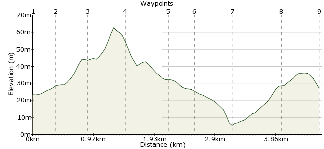
Ascent
59m (193ft)
Descent
82m (269ft)
Max. Elevation
70m (229ft)
Altitude Gain & Loss
141m (462ft)
Start & End
Runton, North Norfolk, Norfolk, England
Distance
4.60km
(2.86mi)
(2.86mi)
Duration
~1:15h
Difficulty
Leisurely
Ordnance Survey Map
A coastal walk between two attractive villages on the north Norfolk coast just outside Cromer. There are various options for different trails, including several waymarked ones, so choose your own adventure! Coastal buses stop in both villages, and there is even a direct service from Norwich.
Walk Functions
Share
Nearby Walks
Sheringham walk
A moderate, circular walk (countryside) starting in Norfolk, England, about 9.60km (5.97 mi) long, duration: ~3:00h.Around Bodham and Holt
A leisurely, walk (countryside) starting in Norfolk, England, about 6.30km (3.91 mi) long, duration: ~1:45h.Blakeney Point on the Norfolk Coast
A leisurely, linear walk (coast) starting in Norfolk, England, about 8.00km (4.97 mi) long, duration: ~2:15h.Walk Map
- $walk->POI array(0)
Waypoints
OS Grid TG199426
The bus stops outside the village shop and tea rooms. Walk west and take the first road on the left.
OS Grid TG197423
Pass under the railway bridge and when you reach the duckpond, head right past the playground. At the end of the green is a road with footpaths marked on it.
About 0.36 km (~0.22 miles) from 
OS Grid TG193421
The path soon splits. You can take a longer walk by taking the left fork, but I opted for the Ingleborough hill option.
About 0.47 km (~0.29 miles) from 
OS Grid TG188423
Follow the tracks through the bracken through this National Trust site.
About 0.52 km (~0.32 miles) from 
OS Grid TG181425
Drop through the golf course towards West Runton. There is also a station here should you prefer to travel by train.
About 0.66 km (~0.41 miles) from 
OS Grid TG180428
Head through the village and past the pub, taking the road down towards the beach.
About 0.38 km (~0.24 miles) from 
OS Grid TG185431
At the beach, you have two options: the clifftop path or a wander along the shingle - but check the tides as you can get cut off in high tides. The third option is chips on the beach and the bus back from West Runton, of course.
About 0.57 km (~0.35 miles) from 
OS Grid TG193428
Via the clifftop park, continue through the caravan park and you soon join the road back to East Runton.
About 0.79 km (~0.49 miles) from 
 East Runton again
OS Grid TG197426
For a small village, it has it all: a shop, pub, fish and chip shop, beach and a lovely little tea room.
About 0.53 km (~0.33 miles) from 
