Mirfield Circular
A moderate walk (countryside) in Yorkshire and the Humber, England, about 10.60km (6.59 mi) long with an estimated walking time of about 3:15h. It is unsuitable for families with children, prams & pushchairs, wheelchairs.
Elevation Profile
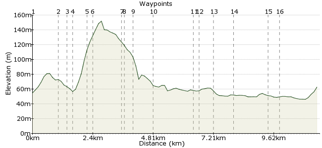
Ascent
138m (452ft)
Descent
122m (400ft)
Max. Elevation
160m (524ft)
Altitude Gain & Loss
260m (852ft)
Start & End
Navigation Tavern, Mirfield, Kirklees, England, WF14 8LT
Distance
10.60km
(6.59mi)
(6.59mi)
Duration
~3:15h
Difficulty
Moderate
Ordnance Survey Map
 2Created by mac.hawk on 14 Nov 2017
A circular walk from Mirfield railway station up Dalton Bank and following old railway lines, river and canal to return. Fantastic view across Huddersfield/Calderdale from Dalton Bank if the weather's kind. Suitable for children with care along the riverbank sections. Mirfield is on the Leeds-Huddersfield/Manchester Victoria railway line. Direct buses available from most West Yorkshire towns south of Leeds/Bradford/Wakefield.
Walk Functions
Share
Nearby Walks
Mirfield Circular over Dalton Bank
A leisurely, circular walk (countryside) starting in West Yorkshire, England, about 9.60km (5.97 mi) long, duration: ~3:00h.Mirfield to Dewsbury along old railway lines
A moderate, linear walk (city/town) starting in West Yorkshire, England, about 10.10km (6.28 mi) long, duration: ~3:00h.Ravensthorpe Rly Sta to Dewsbury Rly Sta
A moderate, circular walk (countryside) starting in West Yorkshire, England, about 16.30km (10.13 mi) long, duration: ~5:15h.Walk Map
- $walk->POI array(0)
Waypoints
OS Grid SE189202
Exit the railway station and follow waymarkers that direct along the Calder Valley Greenway (CVG) down Back Station Road, over the river and to pass Hopton Primary School onto the route of the old railway track.
OS Grid SE179202
Follow the CVG for 3/4 mile to exit onto Helm Lane and turn left (it's well waymarked) for 1/4 mile to enter woodland at right and continue along the tarmac path.
About 1.06 km (~0.66 miles) from 
OS Grid SE176200
Continue through the woodland to reach Bog Green Lane, cross directly taking care as it can be a busy road.
About 0.37 km (~0.23 miles) from 
OS Grid SE175197
Take the short section of the CVG to reach the tunnel under Dalton Bank Road. Exit before reaching the tunnel by taking the path up to Dalton Bank Road itself and turn left.
About 0.24 km (~0.15 miles) from 
OS Grid SE176192
150 yards up the road, and immediately beyond the house on the left, turn left up the wayposted bridleway that is Round Hill Lane. This is a grass path that rises uphill that was obviously once walled (the walls are pretty much ruined nowadays).
About 0.55 km (~0.34 miles) from 
OS Grid SE174191
At the top of the hill reach a wide metal gate by a farm on the left, pass through then almost immediately pass through another wide metal gate on your right to follow the wall on your left to the field perimeter.
About 0.27 km (~0.17 miles) from 
OS Grid SE172180
The path/wall veers slightly to the left & at this point take the obvious path over a minor grassy bank ahead and turn left onto Dalton Bank. Follow the path over the Bank - at the old quarry you can take the high level path on the left or go down into the old quarry itself.
About 1.07 km (~0.66 miles) from 
OS Grid SE170180
Take the path that runs along the right hand lip of the hill to reach Nab Hill and take a short steep path off the hill to reach Jagger Lane and turn right.
About 0.16 km (~0.1 miles) from 
OS Grid SE170184
Follow Jagger Lane downhill to reach Dalton Bank Road and turn right for a quarter of a mile and at the bend in the road take a path on the left to reach a footbridge over an old section of disused railway line.
About 0.39 km (~0.24 miles) from 
OS Grid SE168191
Once over the footbridge simply follow the path that runs alongside the perimeter fence of the chemical works, over the footbridge over the River Colne to reach a tarmac road and turn right.
About 0.74 km (~0.46 miles) from 
OS Grid SE176206
Follow the road towards the old railway bridge ahead and upon reaching it take a path on the left to reach the canal.
About 1.62 km (~1.01 miles) from 
OS Grid SE176208
Turn right at the canal and follow for 1 1/4 miles to where it reaches Lock No1 at the junction with the River Calder. Leave the canal by the footbridge and exit onto Leeds Road and turn right taking the road over the river.
About 0.21 km (~0.13 miles) from 
OS Grid SE182209
Beyond the river turn right down a short section of canal that soon leads to a footpath running along the left bank of the River Calder.
About 0.58 km (~0.36 miles) from 
OS Grid SE189205
After a little over 1/4 mile cross a footbridge over the river to reach another canal section and carry on ahead for just over half a mile to reach the marina at Battyeford.
About 0.87 km (~0.54 miles) from 
OS Grid SE200196
Beyond Battyeford the footpath returns to the (right hand) river bank for 3/4 mile. Where the path reaches adjacent an old stanchion in the river take a path on the right around old derelict buildings beyond which take the road at far left to run adjacent the river towards the railway bridge ahead.
About 1.36 km (~0.85 miles) from 
 Back Station Road
OS Grid SE200191
Reach Back Station Road and retrace your route back to the railway station.
About 0.47 km (~0.29 miles) from 
