Cold Kitchen Hill, Bidcombe Hill and Shear Water
A leisurely walk (countryside) in Wiltshire, England, about 10.20km (6.34 mi) long with an estimated walking time of about 3:15h. It is unsuitable for families with children, prams & pushchairs, wheelchairs.
Elevation Profile
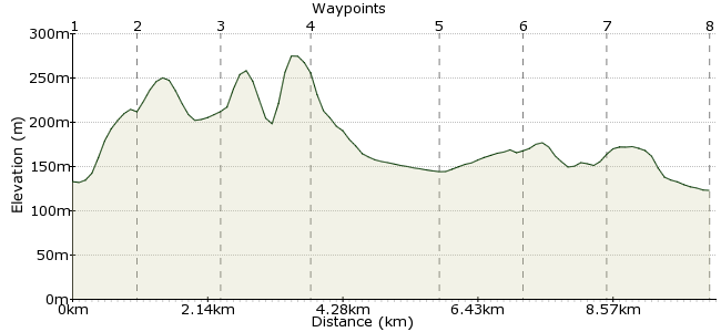
Ascent
153m (501ft)
Descent
165m (541ft)
Max. Elevation
280m (918ft)
Altitude Gain & Loss
318m (1042ft)
Start & End
Kingston Deverill, Kingston Deverill, Wiltshire, England, BA
Distance
10.20km
(6.34mi)
(6.34mi)
Duration
~3:15h
Difficulty
Leisurely
Ordnance Survey Map
This walk in southern Wiltshire explores the very pleasant countryside south of Warminster. Starting with two wooded hills, it continues to Shear Water, a popular weekend walking spot.
There are only three buses a day from Warminster, but it should be easily possible to complete the walk at a leisurely pace between the first and last buses of the day. You can also stay at the Bath Arms in Crockerton if planning a visit to the region.
Walk Functions
Share
Nearby Walks
Hillforts on Salisbury Plain
A moderate, linear walk (countryside) starting in Wiltshire, England, about 14.40km (8.95 mi) long, duration: ~4:45h.Westbury White Horse and Salisbury Plain
A moderate, linear walk (low hills and fells (below 600m)) starting in Wiltshire, England, about 9.90km (6.15 mi) long, duration: ~3:15h.Around Ashcombe Bottom
A moderate, circular walk (countryside) starting in Dorset, England, about 13.60km (8.45 mi) long, duration: ~4:30h.Walk Map
- $walk->POI array(0)
Waypoints
OS Grid ST846371
Take the bus to Kingston Deverill. Look for the church; the footpath starts from there.
OS Grid ST849381
It's a steep start to the day, with a climb up Cold Kitchen Hill.
About 1.01 km (~0.63 miles) from 
OS Grid ST837384
Once you've gained the height, keep to the high ground.
About 1.26 km (~0.78 miles) from 
OS Grid ST827394
Continue on to Bidcombe Hill and drop onto the far side.
About 1.40 km (~0.87 miles) from 
OS Grid ST846402
Through the fields to Rye Hill Farm, where you head north.
About 2.10 km (~1.3 miles) from 
OS Grid ST841413
There's a little section of road walking from Shute Farm.
About 1.22 km (~0.76 miles) from 
OS Grid ST847425
A place I know well, having grown up in Warminster! You can walk along the road-ward southern side, but there are also rough paths on the woodier, northern side.
About 1.29 km (~0.8 miles) from 
 Crockerton
OS Grid ST863423
Continue out via the road to Crockerton, where you can enjoy a drink in the Bath Arms before catching the bus home. The last bus back is around 2:30pm, but if you miss it, you can follow the road for around 2 miles back into Warminster. There is a pavement for the whole way.
About 1.66 km (~1.03 miles) from 

1 comment... join the discussion!
Tim Woods
This is the pub at the end of the walk, a favourite growing up!
www.batharmscrockerton.co.uk