Richmond Park and beyond
A moderate walk (countryside) starting and finishing in Surrey, England, about 11.90km (7.39 mi) long with an estimated walking time of about 3:30h. It is suitable for prams & pushchairs, wheelchairs, but unsuitable for families with children.
Elevation Profile
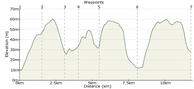
Ascent
61m (200ft)
Descent
43m (141ft)
Max. Elevation
60m (196ft)
Altitude Gain & Loss
104m (341ft)
Start
Richmond
End
Norbiton Station/Wimbledon
Distance
11.90km
(7.39mi)
(7.39mi)
Duration
~3:30h
Difficulty
Moderate
Ordnance Survey Map
One of London's finest parks and well worth a visit. Starting in the attractive town of Richmond, this walk takes you right across the park - you can go off route and explore for yourself as much as you like! Look out for the park's famous deer as well. The route either takes you to Norbiton on the south side of Richmond Park, or continues on across Wimbledon Common.
Walk Functions
Share
Nearby Walks
Richmond & St. Margarets Loop
A leisurely, circular walk (riverside) starting in City of London, England, about 6.70km (4.16 mi) long, duration: ~1:30h.Marble Hill to Bushy Park
A moderate, linear walk (riverside) starting in City of London, England, about 12.20km (7.58 mi) long, duration: ~3:30h.WLH3 walk
A leisurely, circular walk (city/town) starting in Greater London, England, about 7.10km (4.41 mi) long, duration: ~2:00h.Walk Map
- $walk->POI array(0)
Waypoints
OS Grid TQ181752
From Richmond Station, head left through the town centre along The Quadrant and George Street. Then, head up Hill Street and Richmond Hill to the gates of the Park.
OS Grid TQ184737
From here, the choice is yours - the following route is just a suggestion, but the park is well signposted and easy to explore. My favourite route is straight ahead, towards the Pen Ponds.
About 1.56 km (~0.97 miles) from 
OS Grid TQ197727
There are often birds around the ponds, which makes it a pleasant place to stop. From here, head up the hill towards the woods.
About 1.60 km (~0.99 miles) from 
OS Grid TQ195719
Another nice spot, but there are lots to find. The roads which cut through the Park are a plague, but this is one of the quieter places which feel more like the country than a city.
About 0.84 km (~0.52 miles) from 
OS Grid TQ192705
From the southern tip of the Park you can head down Queen's Road to Norbiton Station. If the weather's nice, head East past Coombe Hill and explore Wimbledon Common as well!
About 1.37 km (~0.85 miles) from 
OS Grid TQ213722
This is the edge of Wimbledon Common. As with Richmond Park, don't follow a set route, just lose yourself and explore! Wimbledon Station is not too far the other side of the Common.
About 2.63 km (~1.63 miles) from 
 Wimbledon Station
OS Grid TQ247706
Head home from Wimbledon, well served by buses and trains.
About 3.69 km (~2.29 miles) from 
