Castle Hill Nature Reserve - car-free thanks to cooking oil!
A leisurely walk (low hills and fells (below 600m)) in national park South Downs in East Sussex, England, about 5.50km (3.42 mi) long with an estimated walking time of about 2:00h. It is unsuitable for families with children, prams & pushchairs, wheelchairs.
Elevation Profile
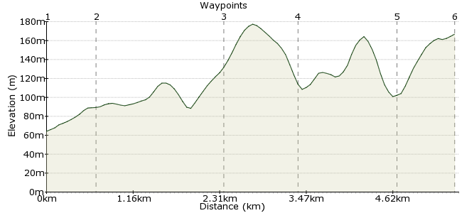
Ascent
143m (469ft)
Descent
40m (131ft)
Max. Elevation
180m (590ft)
Altitude Gain & Loss
183m (600ft)
Start & End
Falmer railway station
Distance
5.50km
(3.42mi)
(3.42mi)
Duration
~2:00h
Difficulty
Leisurely
Ordnance Survey Map
This short walk is close to several other car-free walks on the site, but worth highlighting on its own as one of the finest spots in this part of the South Downs. You'll feel miles from busy city life out here. It's also good for spotting wildlife - hares, foxes, badgers and birds of prey can all be found out here.
For an even more eco-friendly walk, why not travel from Brighton by the Big Lemon bus - run on recycled cooking oil! Check the website for bus times: www.thebiglemon.com
Walk Functions
Share
Nearby Walks
Falmer to Lewes
A moderate, linear walk (low hills and fells (below 600m)) starting in Brighton and Hove, England, about 12.80km (7.95 mi) long, duration: ~4:00h.Basin Stroll
A leisurely, linear walk (countryside) starting in East Sussex, England, about 6.60km (4.10 mi) long, duration: ~2:15h.South Downs Way: Housedean Farm to Pyecombe
A moderate, linear walk (low hills and fells (below 600m)) starting in East Sussex, England, about 11.10km (6.90 mi) long, duration: ~3:30h.Walk Map
- $walk->POI array(0)
Waypoints
OS Grid TQ346087
As Falmer serves two universities, there are regular trains here. You can also catch Big Lemon or Bright and Hove buses here, which stop either outside the station or across the dual carriageway (head for the tunnel under the road).
OS Grid TQ353088
From the station, turn right and follow the road up to Falmer village. Walk through the village to the gateway just before the main road.
About 0.65 km (~0.4 miles) from 
OS Grid TQ365076
Follow the path alongside the road - not the nicest start to a walk, but it gets better! Follow the bridleway that heads east towards Newmarket Plantation. Just before the trees, take the path heading directly uphill.
About 1.70 km (~1.06 miles) from 
OS Grid TQ370068
Drop down the other side of the hill into the nature reserve - time it right and you will have the whole place to yourself to enjoy!
About 0.92 km (~0.57 miles) from 
OS Grid TQ382070
Follow the valley out of the nature reserve and past the old farm buildings. There is a clear path along the valley floor through Balsdean Bottom. The path then heads uphill and joins the South Downs way.
About 1.21 km (~0.75 miles) from 
 Juggs Road Track
OS Grid TQ380077
The South Downs way continues back round to become the Juggs Road. Follow the track back towards Falmer, enjoying fine views back down into the nature reserve.
About 0.77 km (~0.48 miles) from 
