Muncaster Fell and Glannoventa Fort
A moderate walk (low hills and fells (below 600m)) in national park Lake District in Cumbria, England, about 14.50km (9.01 mi) long with an estimated walking time of about 4:15h. It is unsuitable for families with children, prams & pushchairs, wheelchairs.
Elevation Profile
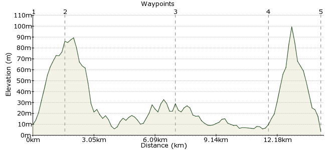
Ascent
78m (255ft)
Descent
84m (275ft)
Max. Elevation
100m (328ft)
Altitude Gain & Loss
162m (530ft)
Start & End
Ravenglass railway station
Distance
14.50km
(9.01mi)
(9.01mi)
Duration
~4:15h
Difficulty
Moderate
Ordnance Survey Map
The West Coast side of the Lake District has some fantastic walks, and is much quieter than the tourist traps in the middle. The West Coast railway line offers easy access to loads of great places to explore. This walk takes you up Muncaster Fell, with a short extension at the end to visit the site of an old Roman Fort.
Walk Functions
Share
Nearby Walks
A three-day Lake District walk
A hard, linear walk (mountain (above 600m)) starting in Cumbria, England, about 37.60km (23.36 mi) long, duration: ~18:15h.Buck Barrow and Whitfell - the quiet corner of the Lakes
A moderate, linear walk (low hills and fells (below 600m)) starting in Cumbria, England, about 17.10km (10.63 mi) long, duration: ~6:30h.An Eskdale ramble
A leisurely, circular walk (riverside) starting in Cumbria, England, about 4.10km (2.55 mi) long, duration: ~1:15h.Walk Map
- $walk->POI array(0)
Waypoints
OS Grid SD085965
Start of the walk. From the station, take the footpath heading through the woods to the site of the Roman Bath House. Follow this through the woods until you meet the road.
OS Grid SD100966
At the corner of the road, take the bridleway up to Muncaster Fell. This becomes a footpath heading along the top of the fell.
About 1.61 km (~1 miles) from 
OS Grid SD148994
As you descend at the north end of Muncaster Fell, pick up the bridleway that follows the south side of the fell and head towards Muncaster village.
About 5.41 km (~3.36 miles) from 
OS Grid SD110967
From the village, take the Cumbria Coastal Way along the north side of the river Esk. This path takes you along to spectacular views of the Eskmeals viaduct and the sea.
About 4.51 km (~2.8 miles) from 
 Glannoventa Roman Fort
OS Grid SD086956
The path follows the dramatic coast, with lots of sand dunes around the mouth of the River Esk. You head back past the Roman ruins into Ravenglass. The trains head north and south along the coast, but if you have to wait then the Ratty Arms pub is right on the station and has lots of local beers.
About 2.63 km (~1.63 miles) from 
