St Sunday Crag and Hartsop over How
A moderate walk (mountain (above 600m)) in national park Lake District in Cumbria, England, about 11.50km (7.15 mi) long with an estimated walking time of about 5:15h. It is unsuitable for families with children, prams & pushchairs, wheelchairs.
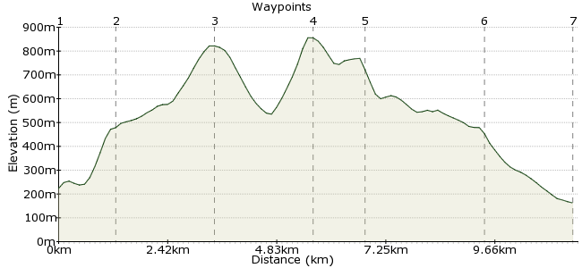
Elevation Profile
Ascent
634m (2080ft)
Descent
696m (2283ft)
Max. Elevation
860m (2821ft)
Altitude Gain & Loss
1330m (4363ft)
Start & End
Patterdale (bus stop)
Distance
11.50km
(7.15mi)
(7.15mi)
Duration
~5:15h
Difficulty
Moderate
Ordnance Survey Map
The Patterdale and Glenridding bus from Penrith opens up endless options for the car-free walker, right in the heart of this stunning region. This walk takes you up St Sunday Crag, across the summit of Fairfield and down along Hartsop over How. Enjoy great views of Ullswater to the north and Windemere to the south.
Walk Functions
Share
Nearby Walks
Grisedale low-level walk
A leisurely, circular walk (low hills and fells (below 600m)) starting in Cumbria, England, about 7.20km (4.47 mi) long, duration: ~2:15h.YHA Patterdale to YHA Grasmere
A moderate, linear walk (mountain (above 600m)) starting in Cumbria, England, about 12.20km (7.58 mi) long, duration: ~5:30h.High Street from Patterdale
A moderate, circular walk (mountain (above 600m)) starting in Cumbria, England, about 15.50km (9.63 mi) long, duration: ~6:30h.Walk Map
- $walk->POI array(0)
Waypoints
OS Grid NY394155
From Patterdale, take the path behind the Post Office. This leads through farmland at the foot of St Sunday Crag. Pass a small patch of woodland and there is a path heading directly uphill after 200m or so.
OS Grid NY383150
The route starts with a tricky little patch heading up through Harrison Crag. From here, the going gets easier as you head up towards Birks. Head to the top of Birks if you want to bag an extra Wainwright.
About 1.23 km (~0.76 miles) from 
OS Grid NY369134
Enjoy cracking view of Hellvellyn, including the mighty Striding Edge. Save the memory for your next car-free walk!
About 2.12 km (~1.32 miles) from 
OS Grid NY359116
Drop off St Sunday via Deepdale Hause, which drops steeply to a small corrie before rising up to the summit of Fairfield via Cofa Pike.
About 2.14 km (~1.33 miles) from 
OS Grid NY368113
This short stretch of ridge walking is actually part of the Fairfield Horseshow. At Hart Crag, head northeast towards Hartsop over How.
About 1.02 km (~0.63 miles) from 
OS Grid NY393125
Hartsop over How doesn't have a summit, but is a pleasant gentle way to head down from the tops. Follow the path heading along the ridge as it curves round towards the Patterdale Valley.
About 2.66 km (~1.65 miles) from 
 Bridgend
OS Grid NY399144
At Bridgend, take the path across the valley. This means you can take the footpath on the east side of the valley, rather than a trudge along the side of the A592. At Rooking, take the small road back to Patterdale. Try the White Lion or the Patterdale Hotel for a beer before you get the bus back.
About 1.99 km (~1.24 miles) from 
