Goatfell and Coire na Ciche on the Isle of Arran
A moderate walk (mountain (above 600m)) starting and finishing in Ayrshire, Scotland, about 10.00km (6.21 mi) long with an estimated walking time of about 5:15h. It is unsuitable for families with children, prams & pushchairs, wheelchairs.
Elevation Profile
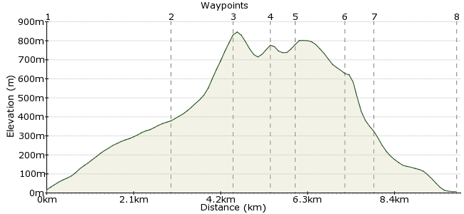
Ascent
860m (2821ft)
Descent
869m (2851ft)
Max. Elevation
850m (2788ft)
Altitude Gain & Loss
1729m (5672ft)
Start
Cladach
End
South Sannox
Distance
10.00km
(6.21mi)
(6.21mi)
Duration
~5:15h
Difficulty
Moderate
Ordnance Survey Map
Ferries count as car-free, right? The Isle of Arran, known as 'Scotland in minature', is a worthwhile trip for any car-free walker. There is a good bus service than runs right around the island from the main town of Brodick, opening up a whole host of walks on this beautiful island.
Goatfell is the highest point on Arran (874m) and also one of the most popular walks. Start from Cladach and head right over the mountain to finish in Sannox.
Walk Functions
Share
Nearby Walks
Goat Fell
A moderate, circular walk (mountain (above 600m)) starting in Ayrshire, Scotland, about 14.00km (8.70 mi) long, duration: ~6:30h.Cir Mhor from Mid Sannox
A moderate, circular walk (mountain (above 600m)) starting in Ayrshire, Scotland, about 12.10km (7.52 mi) long, duration: ~5:45h.The Cock of Arran
A moderate, circular walk (coast) starting in Ayrshire, Scotland, about 10.10km (6.28 mi) long, duration: ~3:00h.Walk Map
- $walk->POI array(0)
Waypoints
OS Grid NS013377
In Cladach, look for the signed footpath to Goatfell. The path starts along a track through woodland, before opening out onto a footpath that runs alongside Cnocan Burn.
OS Grid NS001405
The path is easy to follow and one of the main routes up Goatfell. Continue heading north into Coire nam Meann.
About 3.04 km (~1.89 miles) from 
OS Grid NR990415
The path continues up the corrie to the summit of Goatfell (874m), one of four Corbetts on the Isle of Arran. On a clear day, you can see where the moniker 'Scotland in minature' comes from - rugged hills to the north, with gently rolling countryside to the south. And probably some rain on the way.
About 1.46 km (~0.91 miles) from 
OS Grid NR989424
Follow the Stacach ridge to North Goatfell. Not the most imaginative name for a summit, but at least it makes sense!
About 0.85 km (~0.53 miles) from 
OS Grid NR994428
From North Goatfell, take the ridge running northeast to Mullach Bridge. The route going to Cir Mhor is also a classic - make a mental note for your next day out!
About 0.60 km (~0.37 miles) from 
OS Grid NR998438
Continue along the northerly ridge from Mullach Buidhe towards Cioch na h-Oighe. This ridge overlooks the steep cliffs of Coire na Ciche - also known as the Devil's Punchbowl.
About 1.11 km (~0.69 miles) from 
OS Grid NS004441
The path drops off the end of Cioch na h-Oighe and meets up with the Allt a' Chapuill, the mountain burn that runs into Sannox. Just follow the path alongside the burn.
About 0.64 km (~0.4 miles) from 
 Sannox
OS Grid NS016455
The route finishes in the small hamlet of Sannox, strewn along the ring road that circuits Arran. If you have to wait for the bus to your next destination, take the short stroll to Sannox Bay. There is also a pub and restaurant in the Sannox Bay Hotel if you need refreshing.
About 1.91 km (~1.19 miles) from 
