A view of the Ouse Valley Viaduct
A leisurely walk (countryside) starting and finishing in West Sussex, England, about 9.70km (6.03 mi) long with an estimated walking time of about 2:45h. It is unsuitable for families with children, prams & pushchairs, wheelchairs.
Elevation Profile
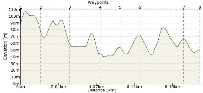
Ascent
25m (82ft)
Descent
61m (200ft)
Max. Elevation
110m (360ft)
Altitude Gain & Loss
86m (282ft)
Start
Balcombe
End
Haywards Heath
Distance
9.70km
(6.03mi)
(6.03mi)
Duration
~2:45h
Difficulty
Leisurely
Ordnance Survey Map
The Ouse Valley Viaduct is an icon of Sussex. Built in 1841, it is a magnificent structure with 37 arches, set amidst the beautiful rolling countryside of Sussex. The viaduct - which took 11 million bricks to build - will be familiar to anyone who has taken the London to Brighton train. And it looks even better from ground level! This walk starts in Balcombe and finishes in Haywards Heath, both easy to reach by bus or train (but it should be by train really for this walk!)
Walk Functions
Share
Nearby Walks
Broadstone Warren in Ashdown Forest
A leisurely, circular walk (woodland) starting in East Sussex, England, about 5.90km (3.67 mi) long, duration: ~2:00h.A walk of two halves
A moderate, linear walk (countryside) starting in East Sussex, England, about 18.60km (11.56 mi) long, duration: ~6:00h.Windmills and a war memorial in the Downs
A leisurely, linear walk (low hills and fells (below 600m)) starting in East Sussex, England, about 6.20km (3.85 mi) long, duration: ~2:00h.Walk Map
- $walk->POI array(0)
Waypoints
OS Grid TQ306302
From Balcombe Station, head along Newlands onto Oldlands Avenue. Turn left onto Haywards Heath Road and take the footpath to Balcombe Mill.
OS Grid TQ317304
Just past the mill is a road that cuts across the northern end of Ardingly Reservoir. Head across and take the bridleway that follows the edge of the reservoir.
About 1.05 km (~0.65 miles) from 
OS Grid TQ332297
Cross the reservoir again on the road and join the footpath heading south.
About 1.60 km (~0.99 miles) from 
OS Grid TQ330282
The path heads south at the end of the reservoir and into the valley which the viaduct was built to cross.
About 1.53 km (~0.95 miles) from 
OS Grid TQ320279
Head along the footpath towards the viaduct to get the perfect photo. For the best view, cross the road and take the path right up to the viaduct - you can see those 11 million bricks when you see it from underneath. Then head back towards the wood the way you came.
About 1.05 km (~0.65 miles) from 
OS Grid TQ330276
The path heads south through the wood towards Haywards Heath. This section is actually part of the High Weald Landscape Trail - one of many long distance paths that pass through Sussex.
About 1.04 km (~0.65 miles) from 
OS Grid TQ332254
The footpath takes you right into the town of Hawyards Heath. Follow signs to the station (if you came by train) or to the town centre.
About 2.23 km (~1.39 miles) from 
 Haywards Heath Station
OS Grid TQ330246
Back to the station for those travelling by train. The Star is the best pub nearby if you have to wait for a train (about 500m - head south along Perrymount Road).
About 0.85 km (~0.53 miles) from 
