Basin Stroll
A leisurely walk (countryside) in national park South Downs starting and finishing in East Sussex, England, about 6.60km (4.10 mi) long with an estimated walking time of about 2:15h. It is unsuitable for families with children, prams & pushchairs, wheelchairs.
Elevation Profile
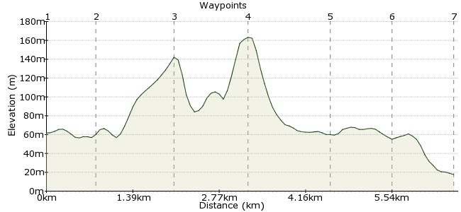
Ascent
107m (351ft)
Descent
152m (498ft)
Max. Elevation
170m (557ft)
Altitude Gain & Loss
259m (849ft)
Start
Housedean Farm
Distance
6.60km
(4.1mi)
(4.1mi)
Duration
~2:15h
Difficulty
Leisurely
Ordnance Survey Map
A walk from near Falmer leading to the beautiful old town of Lewes.
Walk Functions
Share
Nearby Walks
South Downs Way: Housedean Farm to Pyecombe
A moderate, linear walk (low hills and fells (below 600m)) starting in East Sussex, England, about 11.10km (6.90 mi) long, duration: ~3:30h.Castle Hill Nature Reserve - car-free thanks to cooking oil!
A leisurely, circular walk (low hills and fells (below 600m)) starting in East Sussex, England, about 5.50km (3.42 mi) long, duration: ~2:00h.Falmer to Lewes
A moderate, linear walk (low hills and fells (below 600m)) starting in Brighton and Hove, England, about 12.80km (7.95 mi) long, duration: ~4:00h.Walk Map
- $walk->POI array(0)
Waypoints
OS Grid TQ363091
Start of the walk
OS Grid TQ371090
After crossing over the motorway bridge, you will find yourself walking into the farm itself.
About 0.74 km (~0.46 miles) from 
OS Grid TQ368078
You will want to stop around the basin many times to look at beautiful countryside views.
About 1.28 km (~0.8 miles) from 
OS Grid TQ380079
Coming out of the basin.
About 1.19 km (~0.74 miles) from 
OS Grid TQ390087
A quiet cute village to cut through.
About 1.28 km (~0.8 miles) from 
OS Grid TQ399090
The beginning of Juggs Road.
About 0.93 km (~0.58 miles) from 
 The Swan
OS Grid TQ407095
Where Juggs Road and Kingston Road meet.
About 0.98 km (~0.61 miles) from 
